
North Goa topographic map
Interactive map
Click on the map to display elevation.
About this map
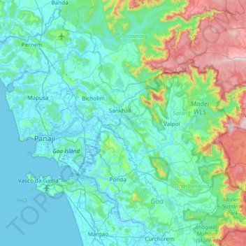
Name: North Goa topographic map, elevation, terrain.
Location: North Goa, Goa, India (15.40809 73.67560 15.80076 74.28236)
Average elevation: 194 m
Minimum elevation: -3 m
Maximum elevation: 1,031 m
Other topographic maps
Click on a map to view its topography, its elevation and its terrain.
Panaji
Panaji was annexed by India with the rest of Goa and the former Portuguese territories after the Indian annexation of Portuguese India in 1961. It became a state-capital on Goa's elevation to statehood in 1987. Between 1961 and 1987, it was the capital of the Union Territory of Goa, Daman and Diu. A new…
Average elevation: 19 m
Mapusa
Mapusa is located at 15°36′N 73°49′E / 15.60°N 73.82°E / 15.60; 73.82. It has an average elevation of 15 metres (49 feet). It lies on the banks of Mapusa River. Mapusa has a tropical climate with temperatures ranging from a high of 37 °C in summer with high levels of humidity to a low of 21 °C in winters.
Average elevation: 26 m
Mapusa
Mapusa is located at 15°36′N 73°49′E / 15.60°N 73.82°E / 15.60; 73.82. It has an average elevation of 15 metres (49 feet).It lies on the banks of Mapusa River. Mapusa has a tropical climate with temperatures ranging from a high of 37 °C in summer with high levels of humidity to a low of 21 °C in winters.
Average elevation: 26 m