
Bangalore Urban topographic map
Interactive map
Click on the map to display elevation.
About this map
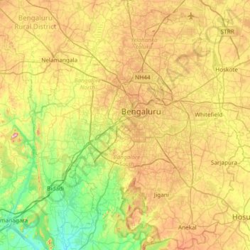
Name: Bangalore Urban topographic map, elevation, terrain.
Location: Bangalore Urban, Karnataka, India (12.65720 77.33445 13.23083 77.83652)
Average elevation: 856 m
Minimum elevation: 650 m
Maximum elevation: 1,199 m
Other topographic maps
Click on a map to view its topography, its elevation and its terrain.
Mysuru
India > Karnataka > Mysuru taluk
Mysore (/maɪˈsɔːr/ (listen)), officially Mysuru ([ˈmaɪˈsuːɾu] (listen)), is a city in the southern part of the state of Karnataka, India. Mysore city is geographically located between 12° 18′ 26″ north latitude and 76° 38′ 59″ east longitude. It is located at an altitude of 770 m (2,530 ft)…
Average elevation: 727 m
Yelanduru
India > Karnataka > Yalanduru taluk
Yelandur is located at 12°04′N 77°02′E / 12.07°N 77.03°E / 12.07; 77.03. It has an average elevation of 555 metres (1820 feet). Yalandur is the taluk and city in Chamarajanagar district in Karnataka state of India. It consists of 33 villages. It is situated about 59 km south-west of Mysuru and…
Average elevation: 660 m
Mangaluru
India > Karnataka > Mangaluru taluk
Mangalore is also the administrative headquarters of the Dakshina Kannada district; it is a commercial, industrial, educational, healthcare, and startup hub. The city's international airport is the second-largest and second-busiest airport in Karnataka. Mangalore City Corporation is responsible for the civic…
Average elevation: 25 m
Channagiri
India > Karnataka > Channagiri taluku
Channagiri is located at 14°02′N 75°56′E / 14.03°N 75.93°E / 14.03; 75.93. It has an average elevation of 662 metres (2171 feet).
Average elevation: 679 m
Udupi
India > Karnataka > Udupi taluku
Udupi has an elevation of 27 m (89 ft) above mean sea level. The climate in Udupi is hot in summers and pleasant in winter. During summers (from March to May) the temperature reaches up to 38 °C (100 °F) and in winters (from December to February) it is usually between 32 and 20 °C (90 and 68 °F). As it is…
Average elevation: 17 m
Chintamani
India > Karnataka > Chintamani taluk
Chintamani lies in the southeast of the South Indian state of Karnataka. It is in the heart of the Mysore Plateau at an average elevation of 865 m (2,838 ft). The Taluk geographically lies between 78°12′36″N 13°16′38″E / 78.21000°N 13.27722°E / 78.21000; 13.27722 and 77°51′39″N…
Average elevation: 886 m
Kudremukha
India > Karnataka > Kalasa taluk
The town of Kudremukha (KIOCL & etc.) lies at an elevation of around 815 metres (2,674 ft), whereas the peak stands at 1,894 metres (6,214 ft). The southern and western sides of the park form the steep slope of the Western Ghats ridgeline, with the altitude varying from 100 m - 1892 m (peak). The northern,…
Average elevation: 858 m
Channapattana
India > Karnataka > Channapattana taluk
Channapatna has an average elevation of 739 metres (2424 ft).
Average elevation: 674 m
Mysuru
India > Karnataka > Mysuru taluk
Mysore (/maɪˈsɔːr/ (listen)), officially Mysuru ([ˈmaɪˈsuːɾu] (listen)), is a city in the southern part of the state of Karnataka, India. Mysore city is geographically located between 12° 18′ 26″ north latitude and 76° 38′ 59″ east longitude. It is located at an altitude of 770 m (2,530 ft)…
Average elevation: 727 m
Karighatta
India > Karnataka > Srirangapattana taluk > Srinivasapura Agrahara
Average elevation: 695 m
Khanapur
India > Karnataka > Khanapura taluku
Khanapur has an elevation of 646 metres (2,119 ft).
Average elevation: 668 m
Chikkamagaluru
India > Karnataka > Chikkamagaluru taluku
Chikmagalur is situated in the Malenadu region of Karnataka in the Deccan plateau in the foothills of the Western Ghats. It is situated at an elevation of 1,090 metres (3,580 ft) above mean sea level, meaning it is the third highest city in Karnataka. The Yagachi River has its source near the town and flows in…
Average elevation: 1,052 m
Kalaburagi
India > Karnataka > Kalaburagi taluku
The entire district is on the Deccan Plateau, and the elevation ranges from 300 to 750 m above MSL. Two main rivers, the Krishna and Bhima, flow through the district. The predominant soil type is black soil. The district has many tanks, which irrigate the land along with the river. The Upper Krishna Project is…
Average elevation: 465 m
Bengaluru
India > Karnataka > Bangalore North
Bangalore (/ˈbæŋɡəlɔːr, ˌbæŋɡəˈlɔːr/ BANG-gə-lor, -LOR), officially Bengaluru (Kannada: [ˈbeŋɡɐɭuːɾu] ; ISO: Beṁgaḷūru), is the capital and largest city of the southern Indian state of Karnataka. It has a population of more than 8 million and a metropolitan population of around…
Average elevation: 879 m
Chikkamagaluru
India > Karnataka > Chikkamagaluru taluku
Chikmagalur is situated in the Malenadu region of Karnataka in the Deccan plateau in the foothills of the Western Ghats. It is situated at an elevation of 1,090 metres (3,580 ft) above mean sea level, meaning, it is the third highest city in Karnataka. The Yagachi River has its source near the town and flows…
Average elevation: 1,052 m