
Mexico topographic map
Click on the map to display elevation.
Mexico
Mexico's topography is characterized by a remarkable diversity, featuring rugged mountains, expansive plateaus, and lush coastal plains. The Sierra Madre Occidental and Sierra Madre Oriental mountain ranges run parallel to the country's western and eastern coasts, respectively, creating a central highland known as the Mexican Plateau. This plateau, which extends approximately 1,200 miles (2,000 kilometers) from the U.S. border to central Mexico, varies in elevation and is surrounded by lower coastal regions. Additionally, Mexico is home to significant geographical features such as Pico de Orizaba, the highest peak at 18,491 feet (5,636 meters), and the lowest point at Laguna Salada, which sits 33 feet (10 meters) below sea level. The terrain transitions from arid deserts, like the Sonoran and Chihuahuan deserts, to tropical rainforests in the south, providing a wide range of ecosystems and climates throughout the country.
About this map
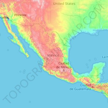
Name: Mexico topographic map, elevation, terrain.
Location: Mexico (14.38118 -118.59919 32.71871 -86.49327)
Average elevation: 412 m
Minimum elevation: -71 m
Maximum elevation: 4,223 m
Other topographic maps
Click on a map to view its topography, its elevation and its terrain.
Vadodara
India > Gujarat > Vadodara Rural Taluka
Vadodara is located at 22°18′N 73°11′E / 22.30°N 73.19°E / 22.30; 73.19 in western India at an elevation of 39 metres (128 ft). It is the tenth-largest city in India with an area of 400 square kilometres (150 sq mi) and a population of 3.5 million, according to the 2010–11 census. The city…
Average elevation: 36 m
Surat
India > Gujarat > Katargam Taluka > Surat
Surat is a port city situated on the banks of the Tapi river. Damming of the Tapi caused the original port facilities to close; the nearest port is now in the Magadalla and Hazira area of Surat Metropolitan Region.It has famous beach called 'Dumas Beach' located in Hazira. The city is located at 21°10′N…
Average elevation: 11 m
Mumbai
Mumbai lies at the mouth of the Ulhas River on the western coast of India, in the coastal region known as the Konkan. It sits on Salsette Island (Sashti Island), which it partially shares with the Thane district. Mumbai is bounded by the Arabian Sea to the west. Many parts of the city lie just above sea level,…
Average elevation: 13 m
Mysuru
India > Karnataka > Mysuru taluk
Mysore (/maɪˈsɔːr/ (listen)), officially Mysuru ([ˈmaɪˈsuːɾu] (listen)), is a city in the southern part of the state of Karnataka, India. Mysore city is geographically located between 12° 18′ 26″ north latitude and 76° 38′ 59″ east longitude. It is located at an altitude of 770 m (2,530 ft)…
Average elevation: 727 m
Cuttack
India > Odisha > Cuttack (M.Corp.) P.S
Cuttack is located at 20°31′23″N 085°47′17″E / 20.52306°N 85.78806°E / 20.52306; 85.78806 and has an average elevation of 36 metres (118 ft). The city is spread across an area of 192.5 km2 (74 sq mi). The city, being a Cuttack Municipal Corporation which consists of 59 wards. The city…
Average elevation: 34 m
Pathanamthitta
Pathanamthitta has an average elevation of 18 metres (62 ft) above sea level.
Average elevation: 63 m
Thiruvananthapuram
India > Kerala > Thiruvananthapuram
Thiruvananthapuram is built on seven hills by the seashore and is at 8°30′N 76°54′E / 8.5°N 76.9°E / 8.5; 76.9 on the west coast, near the southern tip of mainland India. The city is on the west coast of India and is bounded by the Laccadive Sea to its west and the Western Ghats to its east.…
Average elevation: 33 m
Guwahati
Professor Abani Kumar Bhagawati of Gauhati University stated that since before there were sufficient wetlands to absorb rainwater and channels to carry excess water to the Brahmaputra, the city did not experience floods. However, human interference has disrupted the natural topography, leading to the current…
Average elevation: 113 m
Kargil
India > Ladakh > Kargil tehsil
Kargil has an average elevation of 2,676 metres (8,780 feet), and is situated along the banks of the Suru River (Indus). The town of Kargil is located 205 km (127 mi) from Srinagar, facing the Northern Areas across the LOC. Like other areas in the Himalayas, Kargil has a temperate climate. Summers are hot with…
Average elevation: 3,262 m
Rishikesh
India > Uttarakhand > Rishikesh
Rishikesh is at 30°06′12″N 78°17′41″E / 30.103368°N 78.294754°E / 30.103368; 78.294754. It has an average elevation of 340 metres (1,120 ft). The town is located in the Tehri Garhwal region of the northern Indian state of Uttarakhand.
Average elevation: 497 m
Thrissur
Thrissur is the headquarters of Thrissur district, in the centre of the Indian state of Kerala. The city is 75 km north-east of Kochi, 133 km south-west of Coimbatore, 124 km south-east of Kozhikode and 151 km north of Changanacherry. The city is located in a hillock called Thekkinkadu Maidan which is the…
Average elevation: 36 m
Dehradun
India > Uttarakhand > Dehradun
The city of Dehradun mainly lies in Doon Valley and is at a varying height from 410 m (1,350 ft) in Clement Town to above 700 m (2,300 ft) at Malsi which is 15 km (9.3 mi) from the city. However, the average elevation is 450 m (1,480 ft) above sea level. Malsi is the starting point of Lesser Himalayan Range…
Average elevation: 904 m
Salem
Salem is located at 11°40′N 78°08′E / 11.67°N 78.14°E / 11.67; 78.14, at an average elevation of 278 m (912 ft). The city is surrounded by hills: Nagaramalai on the north, Jarugumalai on the south, Kanjamalai on the west, Godumalai on the east and the Shevaroy Hills on the northeast.…
Average elevation: 418 m
Koratagere
India > Karnataka > Koratagere taluku
Koratagere is a Town in Koratagere Taluk in Tumkur District in Karnataka State. 13°31′N 77°14′E / 13.52°N 77.23°E / 13.52; 77.23. It has an average elevation of 750 metres (2460 feet).
Average elevation: 780 m
Chennai
Chennai is located on the south–eastern coast of India in the north–eastern part of Tamil Nadu on a flat coastal plain known as the Eastern Coastal Plains. Its average elevation is around 6.7 metres (22 ft), and its highest point is 60 m (200 ft). Chennai is 2,184 kilometres (1,357 mi) south of Delhi,…
Average elevation: 7 m
Lonavala
India > Maharashtra > Mawal
Adjacent to the Lohagad fort lies the visapur fort which is part of the Lohagad-Visapur fortification. Visapur Fort is larger and at a higher elevation than its twin- Lohagad. It was built during 1713-1720 CE by Balaji Vishwanath.
Average elevation: 613 m
Radhanpur
India > Gujarat > Radhanpur Taluka
Radhanpur is located at 23°50′N 71°36′E / 23.83°N 71.6°E / 23.83; 71.6. It has an average elevation of 27 metres (88 feet).
Average elevation: 30 m
Erattupetta
It has an average elevation of 36 metres (118 feet).
Average elevation: 78 m
Nalgonda
India > Telangana > Nalgonda mandal
Nalgonda is located at 17°03′00″N 79°16′00″E / 17.050°N 79.2667°E / 17.050; 79.2667. It has an average elevation of 420 metres (1,380 ft).
Average elevation: 219 m
Maharashtra
Maharashtra is the third largest state by area in India. The Western Ghats better known as Sahyadri, are a hilly range running parallel to the coast, at an average elevation of 1,200 metres (4,000 ft). Kalsubai, a peak in the Sahyadris, near Nashik city is the highest elevated point in Maharashtra. To the west…
Average elevation: 478 m
Payyanur
India > Kerala > Payyannur Taluk > Payyanur
Payyannur is located at coordinates 12°06′N 75°12′E / 12.1°N 75.2°E / 12.1; 75.2. It has an average elevation of 16 metres (51 feet).
Average elevation: 8 m
Panaji
Panaji was annexed by India with the rest of Goa and the former Portuguese territories after the Indian annexation of Portuguese India in 1961. It became a state-capital on Goa's elevation to statehood in 1987. Between 1961 and 1987, it was the capital of the Union Territory of Goa, Daman and Diu. A new…
Average elevation: 19 m
Leh
Leh (/ˈlɛ/) (Ladakhi: གླེ) is the joint capital and largest city of Ladakh, a union territory of India. Leh, located in the Leh district, was also the historical capital of the Kingdom of Ladakh, the seat of which was in the Leh Palace, the former residence of the royal family of Ladakh, built in the…
Average elevation: 4,294 m
Kandy
Kandy is located in the mountainous and thickly forested interior of the island. The city is located in between multiple mountain ranges including the Knuckles mountain range and the Hanthana Mountain Range, giving the city an elevation of 500 metres (1,600 ft) above sea level. It lies adjacent to the…
Average elevation: 621 m
Udaipur
India > Rajasthan > Girwa Tehsil
Udaipur is located at 24°31′30″N 73°40′38″E / 24.525049°N 73.677116°E / 24.525049; 73.677116. The city covers an area of 64 km2 (25 sq mi) and lies at an altitude of 598.00 m (1,962 ft) above sea level. It is located in the southern region of Rajasthan, near the Gujarat border. The city…
Average elevation: 656 m
Mangaluru
India > Karnataka > Mangaluru taluk
Mangalore is also the administrative headquarters of the Dakshina Kannada district; it is a commercial, industrial, educational, healthcare, and startup hub. The city's international airport is the second-largest and second-busiest airport in Karnataka. Mangalore City Corporation is responsible for the civic…
Average elevation: 25 m
Ankara
Ankara has a cold semi-arid climate (Köppen climate classification: BSk). Under the Trewartha climate classification, Ankara has a temperate humid continental climate (Dc). Due to its elevation and inland location, Ankara has cold and snowy winters, and hot and dry summers. Rainfall occurs mostly during the…
Average elevation: 1,082 m
Kanpur
India > Uttar Pradesh > Kanpur
Situated in the flat Indo-Gangetic Plains, Kanpur has an average elevation of 318 metres (1,043 ft) above sea level. The Ganga flows by the city and several ghats are located on its banks, notably the Sati Chaura Ghat and Sarsaiya Ghat. The Brahmavart Ghat located at Bithoor (25 km northwards) is another ghat…
Average elevation: 124 m
Gondal
India > Gujarat > Gondal Taluka
Gondal is located at 21°58′N 70°48′E / 21.97°N 70.8°E / 21.97; 70.8. It has an average elevation of 132 metres (433 feet).
Average elevation: 143 m
Losal
India > Rajasthan > Danta Ramgarh Tehsil
Losal is located at 27°24′N 74°55′E / 27.4°N 74.92°E / 27.4; 74.92. It has an average elevation of 410 meters (1345 feet). Losal lays 100 km northeast of Jaipur.
Average elevation: 416 m
Vellarada
India > Kerala > Neyyattinkara
Vellarada is also known for its hilltop shrine "Kurisumala Pilgrim Centre" (also called Thekkan kurisumala) at an elevation of 640 metres (2,100 ft). Thousands of devotees from various parts of Tamil Nadu, Kerala, Andhra Pradesh and Karnataka visit the shrine during Lent every year.
Average elevation: 124 m
Gandhinagar
India > Gujarat > Gandhinagar Taluka
Gandhinagar has an average elevation of 81 metres (266 feet). The city sits on the banks of the Sabarmati River, in north-central-east Gujarat. The 20,543 km2 area around Gandhinagar is defined by Gujarat capital territory. Gandhinagar spans an area of 326 km2 (126 sq mi). The river frequently dries up in the…
Average elevation: 75 m