
Bhatsa topographic map
Interactive map
Click on the map to display elevation.
About this map
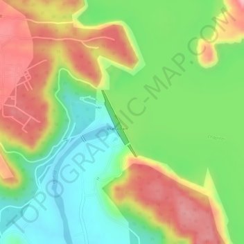
Name: Bhatsa topographic map, elevation, terrain.
Location: Bhatsa, Shahapur, Thane, Maharashtra, India (19.51304 73.41792 19.51376 73.41963)
Average elevation: 130 m
Minimum elevation: 56 m
Maximum elevation: 209 m
Other topographic maps
Click on a map to view its topography, its elevation and its terrain.
Mumbai
India > Maharashtra > Mumbai
Mumbai is on a narrow peninsula on the southwest of Salsette Island, which lies between the Arabian Sea to the west, Thane Creek to the east and Vasai Creek to the north. Mumbai's suburban district occupies most of the island. Navi Mumbai is east of Thane Creek and Thane is north of Vasai Creek. Mumbai…
Average elevation: 18 m
Navi Mumbai
India > Maharashtra > Thane > Navi Mumbai
Navi Mumbai (Marathi pronunciation: , also known by its former name New Bombay), is a planned city off the west coast of the Indian state of Maharashtra in Konkan division. The city is divided into two parts, North Navi Mumbai and South Navi Mumbai, for the individual development of Panvel Mega City, which…
Average elevation: 30 m
Pune
Pune lies on the western margin of the Deccan plateau, at an altitude of 560 m (1,840 ft) above sea level. It is on the leeward side of the Sahyadri mountain range, which forms a barrier from the Arabian Sea. It is a hilly city, with Vetal Hill rising to 800 m (2,600 ft) above sea level. The Sinhagad fort is…
Average elevation: 616 m
Ratnagiri
An outstanding feature of the geography of the district is its uneven or hill topography, with about 45% of the district being characterized as 'hilly'. Very narrow riverine plains fringe the coastline.
Average elevation: 301 m
Pune
Pune lies on the western margin of the Deccan plateau, at an altitude of 560 m (1,840 ft) above sea level. It is on the leeward side of the Sahyadri mountain range, which forms a barrier from the Arabian Sea. It is a hilly city, with Vetal Hill rising to 800 m (2,600 ft) above sea level. The Sinhagad fort is…
Average elevation: 616 m
Chandur Railway
Chandur Railway is located at 20.8142° N, 77.9767° E . It has an average elevation of 332 metres (1089 feet).
Average elevation: 319 m
Navi Mumbai
India > Maharashtra > Thane Taluka
Navi Mumbai (Marathi pronunciation: [nəʋiː mumbəiː]), is a planned city situated on the west coast of the Indian subcontinent, located in the Konkan division of Maharashtra state, on the mainland of India. Navi Mumbai is part of the Mumbai Metropolitan Region (MMR). The city is divided into two, North…
Average elevation: 22 m
Buldhana District
Lonarkar Top (about 923 meters) is highest altitude in Buldhana District placed in Ambabarwa Wildlife Sanctuary.
Average elevation: 425 m
Murtijapur
Murtijapur is located at an average elevation of 308 metres (1210 feet). It is an important railway junction station in Akola district. It is under the Bhusawal-Badnera Section of Bhusawal Division of Central Railway.
Average elevation: 308 m
Pune
Pune lies on the western margin of the Deccan plateau, at an altitude of 560 m (1,840 ft) above sea level. It is on the leeward side of the Sahyadri mountain range, which forms a barrier from the Arabian Sea. It is a hilly city, with Vetal Hill rising to 800 m (2,600 ft) above sea level. The Sinhagad fort is…
Average elevation: 616 m
Daryapur
Daryapur is located at 20.9300° N, 77.3300° E and coordinates at an average elevation of 288m .https://www.latlong.net/place/daryapur-maharashtra-india-11715.html
Average elevation: 295 m
Kolhapur
India > Maharashtra > Karvir
Kolhapur is an inland city located in south-west Maharashtra state, 373 km (232 mi) south of Mumbai and 228 km (142 mi) south of Pune, 615 km (382 mi) north-west of Bengaluru and 530 km (330 mi) west of Hyderabad. Within Maharashtra, Kolhapur's nearest cities and towns are Ichalkaranji 27 km (17 mi), Kodoli 35…
Average elevation: 592 m
Lonavala
India > Maharashtra > Mawal
Adjacent to the Lohagad fort lies the visapur fort which is part of the Lohagad-Visapur fortification. Visapur Fort is larger and at a higher elevation than its twin- Lohagad. It was built during 1713-1720 CE by Balaji Vishwanath.
Average elevation: 613 m
Panvel
India > Maharashtra > Panvel > Panvel
Matheran is a hill station and a municipal council in the Raigad district in the Indian state of Maharashtra. It is a hill station in Karjat Tahsil and is also the smallest hill station in India. It is located on the Western Ghats range at an elevation of around 800 m (2,625 feet) above sea level. It is…
Average elevation: 75 m
Dharashiv
India > Maharashtra > Dharashiv
The city of Osmanabad has an elevation of 653 metres (2,142 ft). Osmanabad is located in the west-central part of Osmanabad Tahsil. Nearby towns include Tuljapur, Bhoom, Paranda, Washi, and Kalamb. Solapur, located southwest of Osmanabad in Solapur district, is the nearest sizeable city. Osmanabad is on the…
Average elevation: 619 m
Karad
India > Maharashtra > Karad
Karad is located at 17°17′N 74°12′E / 17.28°N 74.2°E / 17.28; 74.2. It has an average elevation of 566 metres (1857 feet). Karad is located near Agashiva caves 17°14′15″N 74°09′07″E / 17.237506°N 74.15205°E / 17.237506; 74.15205.
Average elevation: 580 m
Sawantwadi
India > Maharashtra > Sawantwadi Taluka
Sawantwadi is located at 16°00′N 73°45′E / 16°N 73.75°E / 16; 73.75 in the Sindhudurg district of Maharashtra. It has an average elevation of 22 metres (72 ft) above mean sea level. It is the administrative headquarters of the Sindhudurg district. Sawantwadi is situated on the west coast of…
Average elevation: 116 m
Karad
India > Maharashtra > Karad
Karad is located at 17°17′N 74°12′E / 17.28°N 74.2°E / 17.28; 74.2. It has an average elevation of 566 metres (1857 feet). Karad is located near Agashiva caves 17°14′15″N 74°09′07″E / 17.237506°N 74.15205°E / 17.237506; 74.15205.
Average elevation: 580 m