
England topographic map
Interactive map
Click on the map to display elevation.
England
England's topography is characterized by a diverse landscape that transitions from low-lying plains to rugged uplands. In the north and west, the terrain is dominated by mountain ranges such as the Pennines, often referred to as the "backbone of England," and the Lake District, which includes Scafell Pike, the country's highest peak at 978 meters (3,210 feet). These areas feature steep slopes, deep valleys, and numerous lakes, offering dramatic vistas and varied ecosystems. In contrast, the southern and eastern regions are marked by rolling hills, fertile plains, and expansive lowlands like the Fens, resulting from ancient glacial activity. The coastline is equally varied, with the white chalk cliffs of Dover in the southeast, the rugged cliffs of Cornwall in the southwest, and the sandy beaches of East Anglia in the east. This varied topography not only defines England's natural beauty but also influences its climate, agriculture, and human settlement patterns.
About this map
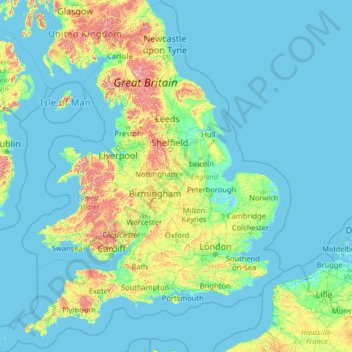
Name: England topographic map, elevation, terrain.
Location: England, United Kingdom (49.67400 -6.70475 55.91700 2.09191)
Average elevation: 55 m
Minimum elevation: -3 m
Maximum elevation: 966 m
Other topographic maps
Click on a map to view its topography, its elevation and its terrain.
Edinburgh
United Kingdom > Scotland > Edinburgh
Some have called Edinburgh the Athens of the North for a variety of reasons. The earliest comparison between the two cities showed that they had a similar topography, with the Castle Rock of Edinburgh performing a similar role to the Athenian Acropolis. Both of them had flatter, fertile agricultural land…
Average elevation: 104 m
Glasgow
United Kingdom > Scotland > Glasgow City
Glasgow itself was reputed to have been founded by the Christian missionary Saint Mungo in the 6th century. He established a church on the Molendinar Burn, where the present Glasgow Cathedral stands, and in the following years Glasgow became a religious centre. Glasgow grew over the following centuries. The…
Average elevation: 128 m
Peterborough
United Kingdom > England > Cambridgeshire
The local topography is flat, and in some places, the land lies below sea level, for example in parts of the Fens to the east and to the south of Peterborough. Human settlement in the area began before the Bronze Age, as can be seen at the Flag Fen archaeological site to the east of the current city centre,…
Average elevation: 17 m
Leeds
Lying in the eastern foothills of the Pennines, there is a significant variation in elevation within the city's built-up area. The district ranges from 1,115 feet (340 m) in the far west on the slopes of Ilkley Moor to about 33 feet (10 m) where the rivers Aire and Wharfe cross the eastern boundary. Land rises…
Average elevation: 94 m
Salisbury
United Kingdom > England > Salisbury
Bishop of Salisbury Hubert Walter was instrumental in the negotiations with Saladin during the Third Crusade, but he spent little time in his diocese prior to his elevation to archbishop of Canterbury. The brothers Herbert and Richard Poore succeeded him and began planning the relocation of the cathedral into…
Average elevation: 96 m
Snowdon
United Kingdom > Wales > Gwynedd
Snowdon (/ˈsnoʊdən/) or Yr Wyddfa (pronounced [ər ˈʊɨ̞̯ðva] (listen)), is the highest mountain in Wales, at an elevation of 1,085 metres (3,560 ft) above sea level, and the highest point in the British Isles outside the Scottish Highlands. It is located in Snowdonia National Park (Parc Cenedlaethol…
Average elevation: 692 m
Cambridge
United Kingdom > England > Cambridge
The city, like most of the UK, has a maritime climate highly influenced by the Gulf Stream. Located in the driest region of Britain, Cambridge's rainfall averages around 570 mm (22.44 in) per year, around half the national average, with some years occasionally falling into the semi-arid (under 500 mm (19.69…
Average elevation: 18 m
Aberdeen
United Kingdom > Scotland > Aberdeen
Two weather stations collect climate data for the area, Aberdeen/Dyce Airport, and Craibstone. Both are about 4 1⁄2 miles (7 km) to the north west of the city centre, and given that they are in close proximity to each other, exhibit very similar climatic regimes. Dyce tends to have marginally warmer daytime…
Average elevation: 52 m
City of London
United Kingdom > England > City of London > City of London
The elevation of the City ranges from sea level at the Thames to 21.6 metres (71 ft) at the junction of High Holborn and Chancery Lane. Two small but notable hills are within the historic core, Ludgate Hill to the west and Cornhill to the east. Between them ran the Walbrook, one of the many "lost" rivers or…
Average elevation: 42 m
Portsmouth
United Kingdom > England > Hampshire > Portsmouth
By road, Portsmouth lies 73.5 miles (118.3 km) from Central London, 49.5 miles (79.7 km) west of Brighton, and 22.3 miles (35.9 km) east of Southampton. Portsmouth is situated primarily on Portsea Island and is the United Kingdom's only island city, although parts of it have expanded onto the mainland. Gosport…
Average elevation: 28 m
Basingstoke
United Kingdom > England > Hampshire > Basingstoke and Deane
Situated in a valley through the Hampshire Downs at an average elevation of 88 metres (289 ft) Basingstoke is a major interchange between Reading, Newbury, Andover, Winchester, and Alton, and lies on the natural trade route between the southwest of England and London. The area had been something of an…
Average elevation: 110 m
Richmond
United Kingdom > England > London
The town centre lies just below 33 ft (10m) above sea level. South of the town centre, rising from Richmond Bridge to an elevation of 165 ft (50m), is Richmond Hill. Just beyond the summit of Richmond Hill is Richmond Park, an area of 2,360 acres (9.55 km2; 3.7 sq mi) of wild heath and woodland originally…
Average elevation: 17 m
Upper Holloway
United Kingdom > England > Derbyshire > Amber Valley > Holloway
Average elevation: 189 m
Tottenham
Tottenham's elevation is approximately 33 ft (10 m) above sea level.
Average elevation: 25 m
Cairn Gorm
United Kingdom > Scotland > Highland
Cairn Gorm (Scottish Gaelic: An Càrn Gorm) is a mountain in the Scottish Highlands. It is part of the Cairngorms range and wider Grampian Mountains. With a summit elevation of 1,245 m (4,085 ft) above sea level, Cairn Gorm is classed as a Munro and is the sixth-highest mountain in the British Isles. The high,…
Average elevation: 989 m
Ben Nevis
United Kingdom > Scotland > Highland
Ben Nevis has a highland (alpine) maritime (oceanic) polar climate (ET climate in the Köppen classification). Ben Nevis's elevation, maritime location and topography frequently lead to cool and cloudy weather conditions, which can pose a danger to ill-equipped walkers. According to the observations carried…
Average elevation: 912 m