
Uttarakhand topographic map
Interactive map
Click on the map to display elevation.
Uttarakhand
Uttarakhand lies on the southern slope of the Himalaya range, and the climate and vegetation vary greatly with elevation, from glaciers at the highest elevations to subtropical forests at the lower elevations. The highest elevations are covered by ice and bare rock. Below them, between 3,000 and 5,000 metres (9,800 and 16,400 ft) are the western Himalayan alpine shrub and meadows. The temperate western Himalayan subalpine conifer forests grow just below the tree line. At 3,000 to 2,600 metres (9,800 to 8,500 ft) elevation they transition to the temperate western Himalayan broadleaf forests, which lie in a belt from 2,600 to 1,500 metres (8,500 to 4,900 ft) elevation. Below 1,500 metres (4,900 ft) elevation lie the Himalayan subtropical pine forests. The Upper Gangetic Plains moist deciduous forests and the drier Terai-Duar savanna and grasslands cover the lowlands along the Uttar Pradesh border in a belt locally known as Bhabar. These lowland forests have mostly been cleared for agriculture, but a few pockets remain.
About this map
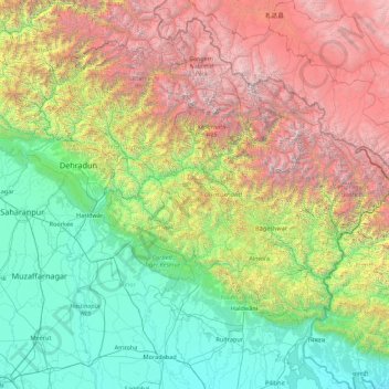
Name: Uttarakhand topographic map, elevation, terrain.
Location: Uttarakhand, India (28.71579 77.57133 31.45902 81.04479)
Average elevation: 2,102 m
Minimum elevation: 160 m
Maximum elevation: 7,442 m
Other topographic maps
Click on a map to view its topography, its elevation and its terrain.
Dehradun
India > Uttarakhand > Dehradun
The city of Dehradun mainly lies in Doon Valley and is at a varying height from 410 m (1,350 ft) in Clement Town to above 700 m (2,300 ft) at Malsi which is 15 km (9.3 mi) from the city. However, the average elevation is 450 m (1,480 ft) above sea level. Malsi is the starting point of Lesser Himalayan Range…
Average elevation: 904 m
Bhowali
India > Uttarakhand > Nainital
Bhowali (Kumaoni: Bhoāli)[bʱəʋaːli] is a town and municipal board in Nainital District in the state of Uttarakhand, India. It is situated at a distance of 11 km (6.8 mi) from the city of Nainital, the district headquarters; at an average elevation of 1,654 m (5,427 ft) from sea level. It is the seat of…
Average elevation: 1,672 m
Mussoorie
India > Uttarakhand > Dehradun
Mussoorie is at an average altitude of 2,005 metres (6,578 ft). To the northeast are the Himalayan snow ranges, and to the south, the Doon Valley and Sivalik Hills ranges. The second highest point is the original Lal Tibba in Landour, with a height of over 2,275 m (7,464 ft). Mussoorie is popularly known as…
Average elevation: 1,594 m
Rishikesh
India > Uttarakhand > Rishikesh
Rishikesh is at 30°06′12″N 78°17′41″E / 30.103368°N 78.294754°E / 30.103368; 78.294754. It has an average elevation of 372 metres (1,220 ft). The town is located in the Tehri Garhwal region of the northern Indian state of Uttarakhand.
Average elevation: 497 m
Dehradun
India > Uttarakhand > Dehradun
The city of Dehradun mainly lies in Doon Valley and is at a varying height from 410 m (1,350 ft) in Clement Town to above 700 m (2,300 ft) at Malsi which is 15 km (9.3 mi) from the city. However, the average elevation is 450 m (1,480 ft) above sea level. Malsi is the starting point of Lesser Himalayan Range…
Average elevation: 904 m
Pithoragarh
India > Uttarakhand > Pithoragarh Tehsil
Pithoragarh is located at 29°35′N 80°13′E / 29.58°N 80.22°E / 29.58; 80.22. in the district of Pithoragarh, Uttarakhand, India. It lies in the revenue Division of Kumaon and is located 188 km northeast of Nainital, the administrative headquarters of Kumaon. It has an average elevation of 1,627…
Average elevation: 1,617 m
Nainital
India > Uttarakhand > Nainital
The city of Nainital covers a total area of 11.73 km2 (4.53 sq mi), and is located at 29°23′N 79°27′E / 29.38°N 79.45°E / 29.38; 79.45, at an average elevation of 2,084 metres (6,837 ft) above sea level. The slopes of the nearby mountains are most populated, with an elevation ranging from…
Average elevation: 1,813 m
Srinagar
India > Uttarakhand > Srinagar
Srinagar is located at 30°13′N 78°47′E / 30.22°N 78.78°E / 30.22; 78.78. at the left bank of Alaknanda river. It has an average elevation of 560 metres (1,837 feet). It is the largest town in the Garhwal Hills. It is reached by national highway NH58 from Rishikesh, Srinagar is about 104 km…
Average elevation: 859 m
Mussoorie
India > Uttarakhand > Dehradun
Mussoorie is at an average altitude of 2,005 metres (6,578 ft). To the northeast are the Himalayan snow ranges, and to the south, the Doon Valley and Shiwalik ranges. The second highest point is the original Lal Tibba in Landour, with a height of over 2,275 m (7,464 ft). Mussoorie is popularly known as The…
Average elevation: 1,594 m
Gomukh, Ice Cave
India > Uttarakhand > Bhatwari
Around the snout, nature presents a wild topography. There are boulders scattered here and there with some pieces of broken snow, along with the hard clayey snow of the glacier.
Average elevation: 4,286 m
Dehradun
India > Uttarakhand > Dehradun
The city of Dehradun mainly lies in Doon Valley and is at a varying height from 410 m (1,350 ft) in Clement Town to above 700 m (2,300 ft) at Malsi which is 15 km (9.3 mi) from the city. However, the average elevation is 450 m (1,480 ft) above sea level. Malsi is the starting point of Lesser Himalayan Range…
Average elevation: 904 m
Laksar
India > Uttarakhand > Laksar
Laksar has an average elevation of 227 metres (745 feet). It is situated between the towns of Khanpur and Sultanpur, and close to the towns of Pathri, Jhabrera and Roorkee in Haridwar district.
Average elevation: 238 m
Rāmnagar
India > Uttarakhand > Ramnagar
It has an average elevation of roughly 345 metres (1,132 feet). Ramnagar is located at the foothills of the Himalayas on the bank of river Kosi. The town is visited by many tourists due to its geographical location near Corbett National Park. Its proximity to Nainital which is a famous hill station of Northern…
Average elevation: 391 m
Valley of Flowers National Park
India > Uttarakhand > Joshimath Tehsil > Ghangaria
Average elevation: 4,606 m
Milam Glacier
India > Uttarakhand > Munsiari tehsil
Milam Glacier, covering around 37 km2 (14 sq mi) area of 16 km (10 mi) length, is located about 15 kilometres (9 mi) northeast of Nanda Devi. It ranges in elevation from about 5,500 metres (18,000 ft) to about 3,870 metres (12,700 ft) at its snout. Situated on the south facing slope of the main Great Himalayas…
Average elevation: 5,229 m
Rāmnagar
India > Uttarakhand > Ramnagar
It has an average elevation of roughly 345 metres (1,132 feet). Ramnagar is located at the foothills of the Himalayas on the bank of river Kosi. The town is visited by many tourists due to its geographical location near Corbett National Park. Its proximity to Nainital which is a famous hill station of Northern…
Average elevation: 391 m
Srinagar
India > Uttarakhand > Srinagar
Srinagar is located at 30°13′N 78°47′E / 30.22°N 78.78°E / 30.22; 78.78. at the left bank of Alaknanda river. It has an average elevation of 560 metres (1,837 feet). It is the largest town in the Garhwal Hills. It is reached by national highway NH58 from Rishikesh, Srinagar is about 104 km…
Average elevation: 859 m
Dehradun
India > Uttarakhand > Dehradun
The city of Dehradun mainly lies in Doon Valley and is at a varying height from 410 m (1,350 ft) in Clement Town to above 700 m (2,300 ft) at Malsi which is 15 km (9.3 mi) from the city. However, the average elevation is 450 m (1,480 ft) above sea level. Malsi is the starting point of Lesser Himalayan Range…
Average elevation: 904 m