
Make a donation
Punjab topographic map
Click on the map to display elevation.
Make a donation
Punjab
Punjab is in northwestern India and has a total area of 50,362 square kilometres (19,445 sq mi). Punjab is bordered by Pakistan's Punjab province on the west, Jammu and Kashmir on the north, Himachal Pradesh on the northeast and Haryana and Rajasthan on the south. Most of Punjab lies in a fertile, alluvial plain with perennial rivers and an extensive irrigation canal system. A belt of undulating hills extends along the northeastern part of the state at the foot of the Himalayas. Its average elevation is 300 metres (980 ft) above sea level, with a range from 180 metres (590 ft) in the southwest to more than 500 metres (1,600 ft) around the northeast border. The southwest of the state is semi-arid, eventually merging into the Thar Desert. Of the five Punjab rivers, three—Sutlej, Beas and Ravi—flow through the Indian state. The Sutlej and Ravi define parts of the international border with Pakistan.
Make a donation
About this map
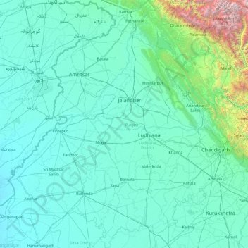
Name: Punjab topographic map, elevation, terrain.
Location: Punjab, India (29.54294 73.87983 32.51118 76.93906)
Average elevation: 477 m
Minimum elevation: 170 m
Maximum elevation: 6,027 m
Make a donation
Other topographic maps
Click on a map to view its topography, its elevation and its terrain.
Mumbai
Mumbai lies at the mouth of the Ulhas River on the western coast of India, in the coastal region known as the Konkan. It sits on Salsette Island (Sashti Island), which it partially shares with the Thane district. Mumbai is bounded by the Arabian Sea to the west. Many parts of the city lie just above sea level,…
Average elevation: 13 m
Make a donation
Nelamangala
India > Karnataka > Nelamangala taluk
{{Infobox settlement | name = Nelamangala | native_name = ನೆಲಮಂಗಲ | native_name_lang = kn | other_name = | nickname = | settlement_type = City | image_skyline = | image_alt = | image_caption = | pushpin_map = India Karnataka#India#Asia | pushpin_label_position = right | pushpin_map_alt = |…
Average elevation: 884 m
Dehradun
India > Uttarakhand > Dehradun
The city of Dehradun mainly lies in Doon Valley and is at a varying height from 410 m (1,350 ft) in Clement Town to above 700 m (2,300 ft) at Malsi which is 15 km (9.3 mi) from the city. However, the average elevation is 450 m (1,480 ft) above sea level. Malsi is the starting point of Lesser Himalayan Range…
Average elevation: 904 m
Maharashtra
Maharashtra is the third largest state by area in India. The Western Ghats better known as Sahyadri, are a hilly range running parallel to the coast, at an average elevation of 1,200 metres (4,000 ft). Kalsubai, a peak in the Sahyadris, near Nashik city is the highest elevated point in Maharashtra. To the west…
Average elevation: 478 m
Make a donation
Make a donation
Chennai
Chennai is located on the south–eastern coast of India in the north–eastern part of Tamil Nadu on a flat coastal plain known as the Eastern Coastal Plains. Its average elevation is around 6.7 metres (22 ft), and its highest point is 60 m (200 ft). Chennai is 2,184 kilometres (1,357 mi) south of Delhi,…
Average elevation: 7 m
Make a donation
Lucknow
India > Uttar Pradesh > Lucknow
The city stands at an elevation of approximately 123 metres (404 ft) above sea level. Lucknow city had an area of 402 km2 (155 square miles) till December 2019, when 88 villages were added to the municipal limits and the area increased to 631 km2 (244 square miles). Bounded on the east by Barabanki, on the…
Average elevation: 120 m
Make a donation
Patna
India > Bihar > Patna Rural
Patna is on the southern bank of the river Ganges. The total area of Patna is 250 km2 (97 sq mi). Of this, the municipal area constitutes 109.218 km2 (42.169 sq mi). The suburban area covers 140.782 km2 (54.356 sq mi). It has an average elevation of 53 m (174 ft). A characteristic feature of the geography of…
Average elevation: 51 m
Make a donation
Make a donation
Make a donation
Make a donation
Dharamshala
India > Himachal Pradesh > Dharamshala
Dharamshala has an average elevation of 1,457 m (4,780 ft), covering an area of almost 8.51 km2 (3.29 sq mi). Dharamsala is located in the Kangra Valley, in the shadow of the Dhauladhar mountains.
Average elevation: 1,781 m
Make a donation
Thiruvananthapuram
India > Kerala > Thiruvananthapuram
Thiruvananthapuram is built on seven hills by the seashore and is at 8°30′N 76°54′E / 8.5°N 76.9°E / 8.5; 76.9 on the west coast, near the southern tip of mainland India. The city is on the west coast of India and is bounded by the Laccadive Sea to its west and the Western Ghats to its east.…
Average elevation: 33 m
Make a donation
Kunigal
India > Karnataka > Kunigal taluk
Kunigal is located at 13°01′N 77°02′E / 13.02°N 77.03°E / 13.02; 77.03. It has an average elevation of 773 metres (2536 feet). It is situated on the National Highway 75 (India) connecting Bengaluru and Mangaluru and State Highway 33 (Karnataka) connecting Tumakuru and Madduru. Kunigal is…
Average elevation: 775 m
Mahesana
India > Gujarat > Mahesana Taluka
Mehsana has an average elevation of 375 feet (114 m) above sea level. By Ahmedabad-Palanpur Railway line, the town is divided in two: the east and western parts are known as Mehsana-1 and Mehsana-2 respectively.
Average elevation: 92 m
Pithoragarh
India > Uttarakhand > Pithoragarh Tehsil
Pithoragarh is located at 29°35′N 80°13′E / 29.58°N 80.22°E / 29.58; 80.22. in the district of Pithoragarh, Uttarakhand, India. It lies in the revenue Division of Kumaon and is located 188 km northeast of Nainital, the administrative headquarters of Kumaon. It has an average elevation of 1,627…
Average elevation: 1,617 m
Make a donation
Lansdowne
India > Uttarakhand > Lansdowne
Lansdowne is a quaint hill station in the Pauri Garhwal district of Uttarakhand, India. Lodged in the picturesque surroundings of the Himalayan ranges, it lies at an elevation of approximately 1,700 meters (5,577 feet) above sea level. The town is about 45 kilometers (28 miles) from the district headquarters,…
Average elevation: 1,140 m
Make a donation
Faridkot
India > Punjab > Faridkot Tahsil
The average elevation is 196 metres (643 ft). The town is located on the Punjab Plains, which in a macro regional context forms a part of greater Satluj Ganga plain. It is a low-lying flat area. The surface of the district is depositional plain which was formed by alleviation by the rivers flowing in these…
Average elevation: 204 m
Arrah
Arrah is located at the elevation of 192 m from the sea level at the bank of Son river, Ganga River and Gangi River. Arrah lies at the confluence of the Ganga and the Son River, other small rivers that flow in the town are Gangi River, Badki Nadi and Chhotki Nadi.
Average elevation: 59 m
Make a donation
Make a donation
Western Ghats
The range starts near south of the Tapti river and runs approximately 1,600 km (990 mi) through the states of Gujarat, Maharashtra, Karnataka, Goa, Kerala and Tamil Nadu ending at Marunthuvazh Malai near the southern tip of India. These hills cover 160,000 km2 (62,000 sq mi) and form the catchment area for…
Average elevation: 2,225 m
Marandahalli
India > Tamil Nadu > Palakkodu
Marandahalli is located at 12°24′N 78°00′E / 12.4°N 78.0°E / 12.4; 78.0. It has an average elevation of 581 metres (1906 feet). Marandahalli is located 40 km from Dharmapuri and 80 km from Bengaluru, 60km from Hosur and 9km from palacode. 10km from Iyyanar kottai. and 15km from Bettamugilalam.
Average elevation: 584 m
Make a donation
Leh
Leh (/ˈlɛ/) (Ladakhi: གླེ) is the joint capital and largest city of Ladakh, a union territory of India. Leh, located in the Leh district, was also the historical capital of the Kingdom of Ladakh, the seat of which was in the Leh Palace, the former residence of the royal family of Ladakh, built in the…
Average elevation: 4,294 m
Make a donation
Amravati
India > Maharashtra > Amravati
Amravati is located at 20°56′N 77°45′E / 20.93°N 77.75°E / 20.93; 77.75. It has an average elevation of 343 meters (1125 feet). It lies 156 km (97 mi) west of Nagpur and serves as the administrative centre of Amravati District and of Amravati Division. The city is located near the passes…
Average elevation: 345 m
Manipal
India > Karnataka > Udupi taluku
Manipal is a suburb and university town within Udupi, in coastal Karnataka, India. Manipal is located five kilometres away from the centre of Udupi City, in Udupi District, Karnataka (state) in south western India. It is administered by the Udupi City Municipality. The suburb is located in coastal Karnataka,…
Average elevation: 32 m
Vellore
India > Tamil Nadu > Vellore
Vellore is at 12°55′N 79°08′E / 12.92°N 79.13°E / 12.92; 79.13, 220m above sea level. The city has a tropical savanna climate. It is in the Vellore district of the South Indian state, Tamil Nadu, 135 km (84 mi) west of the state capital Chennai and 30 km (19 mi) kms South of its twin city…
Average elevation: 283 m
Vadodara
India > Gujarat > Vadodara Rural Taluka
Vadodara is located at 22°18′N 73°11′E / 22.30°N 73.19°E / 22.30; 73.19 in western India at an elevation of 39 metres (128 ft). It is the tenth-largest city in India with an area of 400 square kilometres (150 sq mi) and a population of 3.5 million, according to the 2010–11 census. The city…
Average elevation: 36 m
Make a donation
Bhavnagar
India > Gujarat > Bhavnagar Taluka
Bhavnagar is a coastal city on the eastern coast of Saurashtra, also known as Kathiawar, located at 21°46′N 72°09′E / 21.77°N 72.15°E / 21.77; 72.15. It has an average elevation of 24 metres (78 ft). It occupies an area of 53.3 km2 (20.6 sq mi) and 5th most populated city of Gujarat. The…
Average elevation: 23 m
Thanjavur
India > Tamil Nadu > Thanjavur
Thanjavur is located at 10°48′N 79°09′E / 10.8°N 79.15°E / 10.8; 79.15 The tributaries of river Cauvery, namely, the Grand Anaicut canal (Pudhaaru), Vadavaaru and Vennaaru rivers flow through the city. Thanjavur is situated in the Cauvery delta, at a distance of 314 km (195 mi) south-west of…
Average elevation: 49 m
Make a donation
Make a donation
Make a donation
Make a donation
Make a donation
Make a donation
Hindupur
India > Andhra Pradesh > Hindupur
Even in summers, the city experiences lower temperatures compared to the rest of the state due to its high elevation. Every Year, The lowest temperature will be around 3 degrees and highest temperature will be around 11 degrees. Average annual rainfall is 551mm.
Average elevation: 623 m
Make a donation