
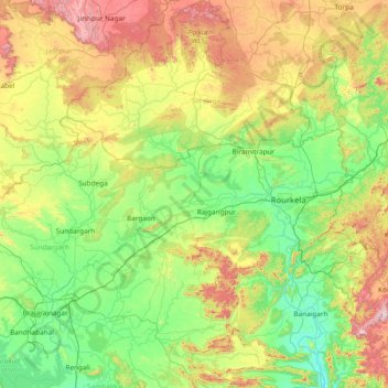
Sundargarh topographic map
Interactive map
Click on the map to display elevation.
About this map
Name: Sundargarh topographic map, elevation, terrain.
Location: Sundargarh, Odisha, 770023, India (21.55000 83.80000 22.95000 85.20000)
Average elevation: 370 m
Minimum elevation: 119 m
Maximum elevation: 1,092 m
Other topographic maps
Click on a map to view its topography, its elevation and its terrain.
Rayagada
The district's tribal population is 57.52 percent of the total. Its 11 blocks have been covered by a tribal sub-plan, with three micro-projects in operation for pre-literate indigenous tribal communities. Rayagada's topography helps the tribal communities maintain their cultural identity; 4,785.36 square…
Average elevation: 522 m
Angul
Angul is located in the centre of the state of Odisha and lies between the latitudes of 20°31′N and 21°40′N and longitudes of 84°15′E and 85°23′E. The altitude is between 564 and 1,187 metres (1,850 and 3,894 ft). The district has an area of 6,232 km2 (2,406 sq mi). It is bounded by Dhenkanal and…
Average elevation: 234 m
Gajapati
The Mahendratanaya River, a tributary of the Banshadhara River, is the primary river flowing through the district. The highest peak in the district is Mahendragiri, standing at 1,501 meters (4,925 feet), followed by Dandamera Parbat at 1,103 meters (3,619 feet) and Tangiri Parbat at 1,155 meters (3,789 feet).…
Average elevation: 341 m
Mayurbhanj
Mayurbhanj's geography is defined by the Simlipal National Park located in the centre of the district. Covering more than a fourth of the district's area, these forests surround the Simlipal Hills, which form the watershed for the district dividing the district into distinct east and west regions. Elevations…
Average elevation: 239 m
Rayagada
The district's tribal population is 57.52 percent of the total. Its 11 blocks have been covered by a tribal sub-plan, with three micro-projects in operation for pre-literate indigenous tribal communities. Rayagada's topography helps the tribal communities maintain their cultural identity; 4,785.36 square…
Average elevation: 522 m
Mayurbhanj
Mayurbhanj's geography is defined by the Simlipal National Park located in the centre of the district. Covering more than a fourth of the district's area, these forests surround the Simlipal Hills, which form the watershed for the district dividing the district into distinct east and west regions. Elevations…
Average elevation: 239 m
Jagatsinghapur
Jagatsinghpur is situated on an elevation of 15 meters (49 feet). It is the smallest district in the state and covers a landmass of 1759 km2. The place lies between 8603' to 86045' East Longitude and between 19058' to 20023' North latitude. It is predominantly recognized due to its triangular geographical…
Average elevation: 6 m
Baripada
India > Odisha > Baripada (M)
Baripada is at 21°56′N 86°43′E / 21.94°N 86.72°E / 21.94; 86.72. It has an average elevation of 36 metres (118 feet). The city lies along the Budhabalanga River.
Average elevation: 41 m
Netaji Subash chandra Bose Park
India > Odisha > Bhubaneswar (M.Corp.) > Bhubaneswar Municipal Corporation
Average elevation: 34 m
Ward 43
India > Odisha > Bhubaneswar (M.Corp.) > Bhubaneswar Municipal Corporation
Average elevation: 28 m
Angul
Angul is located in the centre of the state of Odisha and lies between the latitudes of 20°31′N and 21°40′N and longitudes of 84°15′E and 85°23′E. The altitude is between 564 and 1,187 metres (1,850 and 3,894 ft). The district has an area of 6,232 km2 (2,406 sq mi). It is bounded by Dhenkanal and…
Average elevation: 234 m
Ward 44
India > Odisha > Bhubaneswar (M.Corp.) > Bhubaneswar Municipal Corporation
Average elevation: 21 m