
Fazilka topographic map
Interactive map
Click on the map to display elevation.
About this map
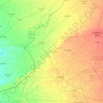
Name: Fazilka topographic map, elevation, terrain.
Location: Fazilka, Punjab, India (29.94699 73.87983 30.72451 74.46289)
Average elevation: 184 m
Minimum elevation: 167 m
Maximum elevation: 203 m
Other topographic maps
Click on a map to view its topography, its elevation and its terrain.
Makhu
India > Punjab > Zira Tahsil
Makhu has an average elevation of 201 metres (659 feet). This town is located near the edge of Harike Sanctuary. It is 5 km away from the confluence of Satluj and Beas rivers.
Average elevation: 210 m
Jagraon
India > Punjab > Jagraon Tahsil
Jagraon is located at 30°47′N 75°29′E / 30.78°N 75.48°E / 30.78; 75.48. It has an average elevation of 234 metres (768 ft).
Average elevation: 234 m
Ludhiana
India > Punjab > Ludhiana (West) Tahsil
Ludhiana is located at 30°54′N 75°51′E / 30.9°N 75.85°E / 30.9; 75.85. It has an average elevation of 244 metres (801 ft). Ludhiana City, to its residents, consists of the Old City and the New City. The new city primarily consists of the Civil Lines area which was historically known as the…
Average elevation: 247 m
Rupnagar
India > Punjab > Rupnagar Tahsil
Rupnagar is located at 30°58′N 76°32′E / 30.97°N 76.53°E / 30.97; 76.53. It has an average elevation of 260 metres (850 ft). The town lies on the bank of Satluj River and the Shivalik hill range spreads along the opposite bank of the river.
Average elevation: 281 m
Amritsar
India > Punjab > Amritsar I Tahsil
Amritsar is located at 31°38′N 74°52′E / 31.63°N 74.87°E / 31.63; 74.87 with an average elevation of 234 metres (768 ft) in the Majha region of the state of Punjab in North India and lies about 15 miles (24 km) east of the border with Pakistan. Administrative towns includes Ajnala, Attari,…
Average elevation: 231 m
Nabha
India > Punjab > Nabha Tahsil
Nabha is located at 30°22′N 76°09′E / 30.37°N 76.15°E / 30.37; 76.15. It has an average elevation of 246 metres (807 feet).
Average elevation: 251 m
Budhlada
India > Punjab > Budhlada Tahsil
Budhlada is located at 29°56′N 75°34′E / 29.93°N 75.57°E / 29.93; 75.57 and has an average elevation of 211 metres (692 ft). The border of Haryana state is 25 kilometres (16 mi) away from the city.
Average elevation: 221 m
Amritsar
India > Punjab > Amritsar I Tahsil
Amritsar is located at 31°38′N 74°52′E / 31.63°N 74.87°E / 31.63; 74.87 with an average elevation of 234 metres (768 ft) in the Majha region of the state of Punjab in North India and lies about 15 miles (24 km) east of the border with Pakistan. Administrative towns includes Ajnala, Attari,…
Average elevation: 231 m
Amritsar
India > Punjab > Amritsar I Tahsil
Amritsar is located at 31°38′N 74°52′E / 31.63°N 74.87°E / 31.63; 74.87 with an average elevation of 234 metres (768 ft). Amritsar is located in the Majha region of the state of Punjab in North India lies about 15 miles (25 km) east of the border with Pakistan. Administrative towns includes…
Average elevation: 231 m
Ludhiana
India > Punjab > Ludhiana (West) Tahsil
Ludhiana is located at 30°54′N 75°51′E / 30.9°N 75.85°E / 30.9; 75.85. It has an average elevation of 244 metres (801 ft). Ludhiana City, to its residents, consists of the Old City and the New City. The new city primarily consists of the Civil Lines area which was historically known as the…
Average elevation: 247 m
Faridkot
India > Punjab > Faridkot Tahsil
The average elevation is 196 metres (643 ft). The town is located on the Punjab Plains, which in a macro regional context forms a part of greater Satluj Ganga plain. It is a low-lying flat area. The surface of the district is depositional plain which was formed by alleviation by the rivers flowing in these…
Average elevation: 204 m
Nabha
India > Punjab > Nabha Tahsil
Nabha is located at 30°22′N 76°09′E / 30.37°N 76.15°E / 30.37; 76.15. It has an average elevation of 246 metres (807 feet).
Average elevation: 251 m