Geolocate

Cheyyar River topographic map

Click on the map to display elevation.

About this map

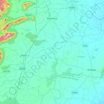
Name: Cheyyar River topographic map, elevation, terrain.

Location: Cheyyar River, North Arcot, Tiruvanamalai district, Tamil Nadu, 606803, India (12.41974 79.03903 12.62749 79.38363)

Average elevation: 181 m

Minimum elevation: 108 m

Maximum elevation: 948 m

Other topographic maps

Click on a map to view its topography, its elevation and its terrain.

Chennai

India > Tamil Nadu

Chennai is located on the southeastern coast of India in the northeastern part of Tamil Nadu on a flat coastal plain known as the Eastern Coastal Plains with an average elevation of 6.7 m (22 ft) and highest point at 60 m (200 ft). Chennai's soil is mostly clay, shale and sandstone. Clay underlies most of the…

Average elevation: 8 m

Alanganallur

India > Tamil Nadu > Vadipatti

Average elevation: 185 m

Chennai

India > Tamil Nadu

Chennai is located on the southeastern coast of India in the northeastern part of Tamil Nadu on a flat coastal plain known as the Eastern Coastal Plains with an average elevation of 6.7 m (22 ft) and highest point at 60 m (200 ft). Chennai's soil is mostly clay, shale and sandstone. Clay underlies most of the…

Average elevation: 8 m

Chennai

India > Tamil Nadu

Chennai is located on the south–eastern coast of India in the north–eastern part of Tamil Nadu on a flat coastal plain known as the Eastern Coastal Plains. Its average elevation is around 6.7 metres (22 ft), and its highest point is 60 m (200 ft). Chennai is 2,184 kilometres (1,357 mi) south of Delhi,…

Average elevation: 7 m

Ilathur

India > Tamil Nadu > Shenkottai

Average elevation: 181 m

Coimbatore

India > Tamil Nadu > Coimbatore North

Average elevation: 452 m

Krishnagiri

India > Tamil Nadu

Average elevation: 653 m

Vellore

India > Tamil Nadu > Vellore

Vellore is at 12°55′N 79°08′E / 12.92°N 79.13°E / 12.92; 79.13, 220m above sea level. The city has a tropical savanna climate. It is in the Vellore district of the South Indian state, Tamil Nadu, 135 km (84 mi) west of the state capital Chennai and 30 km (19 mi) kms South of its twin city…

Average elevation: 283 m

Teppakulam

India > Tamil Nadu > Madurai South > Madurai

Average elevation: 138 m

Coimbatore

India > Tamil Nadu

Apart from the species common to the plains, wild elephants, wild boars leopards, tigers, bison, species of deer, Nilgiri tahr, sloth bear and black-headed oriole can be found. The Anamalai Wildlife Sanctuary 88 km (55 mi) in the Western Ghats at an altitude of 1,400 meters covers an area of 958 km2. More than…

Average elevation: 551 m

Sholinganallur

India > Tamil Nadu

Average elevation: 7 m

Melavatachavady

India > Tamil Nadu > Thanjavur

Average elevation: 75 m

Giingee

India > Tamil Nadu > Gingee

Gingee is located at 12°15′N 79°25′E / 12.25°N 79.42°E / 12.25; 79.42. It has an average elevation of 92 metres (301 ft).

Average elevation: 102 m

Kanniyakumari

India > Tamil Nadu

Kanyakumari district has a varied topography with sea on three sides and the mountains of the Western Ghats bordering the northern side. Except for a small stretch of land to the west of Kanyakumari town, almost the entire district is sandwiched between the Western Ghats and the Arabian Sea - the only district…

Average elevation: 226 m

Agraharam

India > Tamil Nadu > Pallavaram

Average elevation: 22 m

Singampunari

India > Tamil Nadu > Thiruppathur

Average elevation: 154 m

Sengādu

India > Tamil Nadu > Tiruporur

Average elevation: 8 m

Pykara Waterfalls

India > Tamil Nadu > Udhagamandalam > Pykara

Average elevation: 2,084 m

Tiruttani

India > Tamil Nadu

Average elevation: 130 m

Salem

India > Tamil Nadu

Salem is located at 11°40′N 78°08′E / 11.67°N 78.14°E / 11.67; 78.14, at an average elevation of 278 m (912 ft). The city is surrounded by hills: Nagaramalai on the north, Jarugumalai on the south, Kanjamalai on the west, Godumalai on the east and the Shevaroy Hills on the northeast.…

Average elevation: 418 m

Chengalpattu

India > Tamil Nadu > Chengalpattu

Chengalpattu is located at 12°42′N 79°59′E / 12.7°N 79.98°E / 12.7; 79.98. It has an average elevation of 36 metres (118 ft). Lake Kolavai is the largest located in Chengalpattu.

Average elevation: 48 m

Perunagar

India > Tamil Nadu

Average elevation: 80 m

Perampalli

India > Tamil Nadu > Tirupathur

Average elevation: 792 m

T R Bazaar

India > Tamil Nadu > Udhagamandalam

Average elevation: 2,050 m

Panruti

India > Tamil Nadu > Panruti

Panruti is located at 11.77°N 79.55°E. Panruti is located on the main line of high ways. National highway NH-36 passes through this town, connects Vikravandi and Mannargudi. State Highway SH-68 which connects Cuddalore - Sankarapuram passes through Panruti. The town lies in mainway of Chennai and Kumbakonam.…

Average elevation: 32 m

Chittur

India > Tamil Nadu > Iluppur taluk

Average elevation: 108 m

Pichanur

India > Tamil Nadu > Coimbatore South

Average elevation: 221 m

Kulathur

India > Tamil Nadu > Sulur

Average elevation: 378 m

Alandur

India > Tamil Nadu

Average elevation: 16 m

Alangulam

India > Tamil Nadu

Average elevation: 107 m

Alangulam

India > Tamil Nadu

Average elevation: 107 m

The Nilgiris

India > Tamil Nadu

Average elevation: 639 m

Mangalapuram

India > Tamil Nadu > Kumbakonam

Average elevation: 23 m

Vazhkai

India > Tamil Nadu > Papanasam

Average elevation: 30 m

Sembanarkoil

India > Tamil Nadu > Tharangambadi

Average elevation: 8 m

Pudur

India > Tamil Nadu > Modakkurichi

Average elevation: 229 m

Chennai

India > Tamil Nadu

Chennai is located on the south–eastern coast of India in the north–eastern part of Tamil Nadu on a flat coastal plain known as the Eastern Coastal Plains. Its average elevation is around 6.7 metres (22 ft), and its highest point is 60 m (200 ft). Chennai is 2,184 kilometres (1,357 mi) south of Delhi,…

Average elevation: 7 m

Naduveerapattu

India > Tamil Nadu

Average elevation: 22 m

KIlminnal

India > Tamil Nadu > Wallajah

Average elevation: 194 m

Arasur

India > Tamil Nadu > Thiruvaiyaru

Average elevation: 40 m

MKB Nagar

India > Tamil Nadu > Chennai

Average elevation: 6 m

Thiruvarur

India > Tamil Nadu

Average elevation: 16 m

Meppadi

India > Tamil Nadu > Thiruvarur > Thandalai

Average elevation: 11 m

Arasur

India > Tamil Nadu > Sulur

Average elevation: 380 m

Puluguberpalli

India > Tamil Nadu > Vaniyambadi

Average elevation: 499 m

Erode

India > Tamil Nadu

The topography of the district consists of plains sloping from rom north east to south west. The Eastern Ghats run through the north-western part of the district, and is straddled by the Western Ghats in the west, with the mountain ranges separated by the Moyar River. The region comprises the high altitude…

Average elevation: 512 m

Ponneri

India > Tamil Nadu

Average elevation: 6 m

KOLLI HILLS

India > Tamil Nadu

Average elevation: 563 m

Thiruporur

India > Tamil Nadu > Tiruporur

Average elevation: 7 m

Kodiyampalayam

India > Tamil Nadu > Thottiyam

Average elevation: 91 m

Thippirajapuram

India > Tamil Nadu > Kumbakonam

Average elevation: 25 m

Attur

India > Tamil Nadu > Athoor

Average elevation: 299 m

Thalli

India > Tamil Nadu > Denkanikottai

Average elevation: 916 m

Thuvakudi

India > Tamil Nadu > Thiruverumbur

Thuvakudi is located at 10°45′23″N 78°48′04″E / 10.756389°N 78.801111°E / 10.756389; 78.801111. The average elevation is 88 metres (289 ft). The topology of Thuvakudi is almost flat with a few isolated hillocks rising above the surface. The city spread over an area of 14.371 square…

Average elevation: 78 m

Christianpet

India > Tamil Nadu > Katpadi

Average elevation: 279 m

Paranam

India > Tamil Nadu > Sendurai

Average elevation: 97 m

Giingee

India > Tamil Nadu > Gingee

Gingee is located at 12°15′N 79°25′E / 12.25°N 79.42°E / 12.25; 79.42. It has an average elevation of 92 metres (301 ft).

Average elevation: 102 m

Eruvadi

India > Tamil Nadu > Nanguneri

Average elevation: 94 m

Palani

India > Tamil Nadu > Palani

Average elevation: 316 m

Sivaganga

India > Tamil Nadu > Sivaganga

Sivaganga has an average elevation of 102 metres (334 feet). The town has a tropical wet and dry climate. The maximum temperature during summer is 37 °C or 98.6 °F and during winter it is 28 °C or 82.4 °F. The minimum temperature varies from 23.9 to 27.8 °C (75.0 to 82.0 °F). The seasonal climate…

Average elevation: 98 m

Taramangalam

India > Tamil Nadu > Omalur

Average elevation: 263 m

Coimbatore South

India > Tamil Nadu

Average elevation: 459 m

Theresapuram

India > Tamil Nadu

Average elevation: 45 m

Keeranatham

India > Tamil Nadu > Coimbatore North

Average elevation: 413 m

Tiruneermalai

India > Tamil Nadu > Pallavaram

Average elevation: 19 m

Palayamkottai

India > Tamil Nadu

Average elevation: 47 m

Kanniyampettai

India > Tamil Nadu > Mathavaram > Chennai

Average elevation: 4 m

Surandai

India > Tamil Nadu > Veerakeralamputhur

Surandai is located at 8°58′38″N 77°25′14″E / 8.977272°N 77.420568°E / 8.977272; 77.420568. It has an average elevation of 132 metres (433 feet). It is situated 20 km from Coutrallam Falls, 12 km away from Tenkasi and 50 km from Tirunelveli, District Head. It is 30 km away from…

Average elevation: 137 m

Chennai

India > Tamil Nadu

Chennai is located on the southeastern coast of India in the northeastern part of Tamil Nadu on a flat coastal plain known as the Eastern Coastal Plains with an average elevation of 6.7 m (22 ft) and highest point at 60 m (200 ft). Chennai's soil is mostly clay, shale and sandstone. Clay underlies most of the…

Average elevation: 8 m

Lakshmipuram

India > Tamil Nadu > Ambattur

Average elevation: 20 m

Paramakudi

India > Tamil Nadu

Average elevation: 26 m

Pattipulam

India > Tamil Nadu > Tiruporur

Average elevation: 2 m

Sriperumbudur

India > Tamil Nadu

Average elevation: 45 m

Koranadu

India > Tamil Nadu > Mayiladuthurai

Average elevation: 12 m

Madambakkam Lake

India > Tamil Nadu > Tambaram > Noothanchery

Average elevation: 17 m

Paruvai

India > Tamil Nadu > Palladam

Average elevation: 397 m

Thazhambur

India > Tamil Nadu > Tiruporur

Average elevation: 7 m

Kottarai

India > Tamil Nadu > Alathur

Average elevation: 85 m

Kavanur

India > Tamil Nadu > Ramanathapuram

Average elevation: 10 m

Thuraiyur

India > Tamil Nadu

Average elevation: 328 m

Gandhinagar

India > Tamil Nadu > Musiri

Average elevation: 89 m

Killiyur

India > Tamil Nadu > Tharangambadi

Average elevation: 5 m

Manimangalam

India > Tamil Nadu

Average elevation: 21 m

Keezhaiyur

India > Tamil Nadu > Tharangambadi

Average elevation: 7 m

Sholayar Dam

India > Tamil Nadu > Valparai > Sholayar Dam City

Average elevation: 981 m

Bennangur

India > Tamil Nadu > Denkanikottai

Average elevation: 859 m

Tambaram

India > Tamil Nadu > Tambaram

Average elevation: 23 m

annai nagar

India > Tamil Nadu > Aravakurichi > K.Paramathi

Average elevation: 185 m

Senapathy Palayam

India > Tamil Nadu > Erode

Average elevation: 205 m

Avadi

India > Tamil Nadu > Poonamallee

Avadi is located at 13°07′N 80°06′E / 13.12°N 80.1°E / 13.12; 80.1. It covers an area of 65 square kilometres (25 sq mi) and has an average elevation of 17 metres (56 ft). Avadi is one of the largest localities in Chennai, stretching from Poonamalle High Road to MTH Road.

Average elevation: 23 m

Kālavākkam

India > Tamil Nadu > Tiruporur

Average elevation: 6 m

Noothanchery

India > Tamil Nadu > Tambaram

Average elevation: 12 m

Sulur

India > Tamil Nadu

Average elevation: 382 m

Kumulur

India > Tamil Nadu > Lalgudi

Average elevation: 80 m

Pannur

India > Tamil Nadu > Thiruvallur

Average elevation: 79 m

Kadapakkam

India > Tamil Nadu > Cheyyur

Average elevation: 10 m

Coimbatore

India > Tamil Nadu > Coimbatore North

Average elevation: 452 m

Pillaipakkam

India > Tamil Nadu

Average elevation: 31 m

Kunnur

India > Tamil Nadu > Thiruthuraipoondi

Average elevation: 4 m

Vedanārāyanapuram

India > Tamil Nadu > Chengalpattu

Average elevation: 48 m