
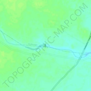
Anaikuttam Dam topographic map
Interactive map
Click on the map to display elevation.
About this map
Name: Anaikuttam Dam topographic map, elevation, terrain.
Average elevation: 96 m
Minimum elevation: 88 m
Maximum elevation: 101 m
Other topographic maps
Click on a map to view its topography, its elevation and its terrain.
Chennai
India > Tamil Nadu > Chennai
Chennai is located on the south–eastern coast of India in the north–eastern part of Tamil Nadu on a flat coastal plain known as the Eastern Coastal Plains. Its average elevation is around 6.7 metres (22 ft), and its highest point is 60 m (200 ft). Chennai is 2,184 kilometres (1,357 mi) south of Delhi,…
Average elevation: 8 m
Coimbatore District
Apart from the species common to the plains, wild elephants, wild boars leopards, tigers, bison, species of deer, Nilgiri tahr, sloth bear and black-headed oriole can be found. The Anamalai Wildlife Sanctuary 88 km (55 mi) in the Western Ghats at an altitude of 1,400 meters covers an area of 958 km2. More than…
Average elevation: 551 m
Chennai
Chennai is located on the south–eastern coast of India in the north–eastern part of Tamil Nadu on a flat coastal plain known as the Eastern Coastal Plains. Its average elevation is around 6.7 metres (22 ft), and its highest point is 60 m (200 ft). Chennai is 2,184 kilometres (1,357 mi) south of Delhi,…
Average elevation: 7 m
Kanniyakumari
Kanyakumari district has a varied topography with sea on three sides and the mountains of the Western Ghats bordering the northern side. Except for a small stretch of land to the west of Kanyakumari town, almost the entire district is sandwiched between the Western Ghats and the Arabian Sea - the only district…
Average elevation: 226 m
Salem
Salem is located at 11°40′N 78°08′E / 11.67°N 78.14°E / 11.67; 78.14, at an average elevation of 278 m (912 ft). The city is surrounded by hills: Nagaramalai on the north, Jarugumalai on the south, Kanjamalai on the west, Godumalai on the east and the Shevaroy Hills on the northeast.…
Average elevation: 418 m
Arcot
India > Tamil Nadu > Arcot
Arcot is located at 12°54′N 79°20′E / 12.9°N 79.33°E / 12.9; 79.33. It has an average elevation of 164 metres (538 ft).
Average elevation: 169 m
Sivakasi
India > Tamil Nadu > Sivakasi
Sivakasi is located at 9°27′00″N 77°49′00″E / 9.45°N 77.8167°E / 9.45; 77.8167 and has an average elevation of 101 metres (331 feet). The city is located in Virudhunagar district of the South Indian state, Tamil Nadu, at a distance of 74 km (46 mi) from Madurai. Sivakasi is located to the…
Average elevation: 104 m
Tirunelveli
India > Tamil Nadu > Tirunelveli
Tirunelveli is located at 8°43′41.82″N 77°41′43.94″E / 8.7282833°N 77.6955389°E / 8.7282833; 77.6955389, and its average elevation is 47 metres (154 ft). It is located at the southernmost tip of the Deccan plateau. The Tamirabarani River divides the city into the Tirunelveli quarter and…
Average elevation: 60 m
Vellore
India > Tamil Nadu > Vellore
Vellore is at 12°55′N 79°08′E / 12.92°N 79.13°E / 12.92; 79.13, 220m above sea level. The city has a tropical savanna climate. It is in the Vellore district of the South Indian state, Tamil Nadu, 135 km (84 mi) west of the state capital Chennai and 30 km (19 mi) kms South of its twin city…
Average elevation: 283 m
Chengalpattu
India > Tamil Nadu > Chengalpattu
Chengalpattu is located at 12°42′N 79°59′E / 12.7°N 79.98°E / 12.7; 79.98. It has an average elevation of 36 metres (118 ft). Lake Kolavai is the largest located in Chengalpattu.
Average elevation: 48 m
Nagapattinam District
The district shares borders with Tiruvarur district of Tamil Nadu and Karaikal district of the union territory Puducherry. The district of Nagapattinam lies on the shores of the Bay of Bengal between latitude 10.7906°N and Longitude 79.8428°E an area of 1,397 square kilometres (539 sq mi). The District…
Average elevation: 4 m
Udumalaipettai
India > Tamil Nadu > Udumalaipettai
The town is surrounded by Western Ghats on three sides. The average altitude of the town is 1208 feet above MSL. The topography is undulated and the general slope is from west to North. The town gets major rainfall during the South West monsoon. The average annual rainfall is 501.40 mm. Black and red soil…
Average elevation: 363 m
Thanjavur
India > Tamil Nadu > Thanjavur
Thanjavur is located at 10°48′N 79°09′E / 10.8°N 79.15°E / 10.8; 79.15 The tributaries of river Cauvery, namely, the Grand Anaicut canal (Pudhaaru), Vadavaaru and Vennaaru rivers flow through the city. Thanjavur is situated in the Cauvery delta, at a distance of 314 km (195 mi) south-west of…
Average elevation: 49 m
Nilgiris
The district has an area of 2,552.50 km2. The district is basically hilly, lying at an elevation of 1,000 to 2,600 metres above MSL, and divided between the Nilgiri plateau and the lower, smaller Wayanad plateau. The district lies at the juncture of the Western Ghats and the Eastern Ghats. Its latitudinal and…
Average elevation: 975 m
Yelagiri
India > Tamil Nadu > Tirupathur
Yelagiri (Tamil: [jeːlaɡiɾi]), also spelled Elagiri, is a hill station located in Tirupathur district of Tamil Nadu, India. Located at an altitude of 1,410 m (4,630 ft), it forms a part of the Eastern Ghats mountain range. The hills consist of 14 hamlets spread across an area of 72 km2 (28 sq mi).
Average elevation: 772 m
Nilakkottai
India > Tamil Nadu > Nilakkottai
Nilakkottai is located at 10°10′N 77°51′E / 10.17°N 77.85°E / 10.17; 77.85. It has an average elevation of 320 metres (1049 feet).
Average elevation: 242 m