
Make a donation
Kallanai topographic map
Click on the map to display elevation.
Make a donation
About this map
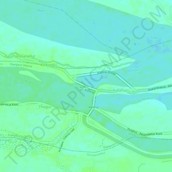
Name: Kallanai topographic map, elevation, terrain.
Average elevation: 60 m
Minimum elevation: 55 m
Maximum elevation: 65 m
Make a donation
Other topographic maps
Click on a map to view its topography, its elevation and its terrain.
Chennai
Chennai is located on the southeastern coast of India in the northeastern part of Tamil Nadu on a flat coastal plain known as the Eastern Coastal Plains with an average elevation of 6.7 m (22 ft) and highest point at 60 m (200 ft). Chennai's soil is mostly clay, shale and sandstone. Clay underlies most of the…
Average elevation: 8 m
Salem
Salem is located at 11°40′N 78°08′E / 11.67°N 78.14°E / 11.67; 78.14, at an average elevation of 278 m (912 ft). The city is surrounded by hills: Nagaramalai on the north, Jarugumalai on the south, Kanjamalai on the west, Godumalai on the east and the Shevaroy Hills on the northeast.…
Average elevation: 418 m
Make a donation
Coimbatore
Apart from the species common to the plains, wild elephants, wild boars leopards, tigers, bison, species of deer, Nilgiri tahr, sloth bear and black-headed oriole can be found. The Anamalai Wildlife Sanctuary 88 km (55 mi) in the Western Ghats at an altitude of 1,400 meters covers an area of 958 km2. More than…
Average elevation: 551 m
Make a donation
Thuvakudi
India > Tamil Nadu > Thiruverumbur
Thuvakudi is located at 10°45′23″N 78°48′04″E / 10.756389°N 78.801111°E / 10.756389; 78.801111. The average elevation is 88 metres (289 ft). The topology of Thuvakudi is almost flat with a few isolated hillocks rising above the surface. The city spread over an area of 14.371 square…
Average elevation: 78 m
Make a donation
Chennai
Chennai is located on the south–eastern coast of India in the north–eastern part of Tamil Nadu on a flat coastal plain known as the Eastern Coastal Plains. Its average elevation is around 6.7 metres (22 ft), and its highest point is 60 m (200 ft). Chennai is 2,184 kilometres (1,357 mi) south of Delhi,…
Average elevation: 7 m
Kanniyakumari
Kanyakumari district has a varied topography with sea on three sides and the mountains of the Western Ghats bordering the northern side. Except for a small stretch of land to the west of Kanyakumari town, almost the entire district is sandwiched between the Western Ghats and the Arabian Sea - the only district…
Average elevation: 226 m
Make a donation
Vellore
India > Tamil Nadu > Vellore
Vellore is at 12°55′N 79°08′E / 12.92°N 79.13°E / 12.92; 79.13, 220m above sea level. The city has a tropical savanna climate. It is in the Vellore district of the South Indian state, Tamil Nadu, 135 km (84 mi) west of the state capital Chennai and 30 km (19 mi) kms South of its twin city…
Average elevation: 283 m
Chennai
Chennai is located on the south–eastern coast of India in the north–eastern part of Tamil Nadu on a flat coastal plain known as the Eastern Coastal Plains. Its average elevation is around 6.7 metres (22 ft), and its highest point is 60 m (200 ft). Chennai is 2,184 kilometres (1,357 mi) south of Delhi,…
Average elevation: 7 m
Chengalpattu
India > Tamil Nadu > Chengalpattu
Chengalpattu is located at 12°42′N 79°59′E / 12.7°N 79.98°E / 12.7; 79.98. It has an average elevation of 36 metres (118 ft). Lake Kolavai is the largest located in Chengalpattu.
Average elevation: 48 m
Make a donation
Zone 14 Perungudi
India > Tamil Nadu > Sholinganallur > Chennai
Perungudi is located at 12°58′N 80°15′E / 12.97°N 80.25°E / 12.97; 80.25. It has an average elevation of 9 metres (29 feet).
Average elevation: 3 m
Make a donation
Make a donation
Giingee
India > Tamil Nadu > Gingee
Gingee is located at 12°15′N 79°25′E / 12.25°N 79.42°E / 12.25; 79.42. It has an average elevation of 92 metres (301 ft).
Average elevation: 102 m
Make a donation
Make a donation
Panruti
India > Tamil Nadu > Panruti
Panruti is located at 11.77°N 79.55°E. Panruti is located on the main line of high ways. National highway NH-36 passes through this town, connects Vikravandi and Mannargudi. State Highway SH-68 which connects Cuddalore - Sankarapuram passes through Panruti. The town lies in mainway of Chennai and Kumbakonam.…
Average elevation: 32 m
Make a donation
Make a donation
Erode
The topography of the district consists of plains sloping from rom north east to south west. The Eastern Ghats run through the north-western part of the district, and is straddled by the Western Ghats in the west, with the mountain ranges separated by the Moyar River. The region comprises the high altitude…
Average elevation: 512 m
Make a donation
Make a donation
Make a donation
Thuvakudi
India > Tamil Nadu > Thiruverumbur
Thuvakudi is located at 10°45′23″N 78°48′04″E / 10.756389°N 78.801111°E / 10.756389; 78.801111. The average elevation is 88 metres (289 ft). The topology of Thuvakudi is almost flat with a few isolated hillocks rising above the surface. The city spread over an area of 14.371 square…
Average elevation: 78 m
Make a donation
Make a donation
Giingee
India > Tamil Nadu > Gingee
Gingee is located at 12°15′N 79°25′E / 12.25°N 79.42°E / 12.25; 79.42. It has an average elevation of 92 metres (301 ft).
Average elevation: 102 m
Make a donation
Sivaganga
India > Tamil Nadu > Sivaganga
Sivaganga has an average elevation of 102 metres (334 feet). The town has a tropical wet and dry climate. The maximum temperature during summer is 37 °C or 98.6 °F and during winter it is 28 °C or 82.4 °F. The minimum temperature varies from 23.9 to 27.8 °C (75.0 to 82.0 °F). The seasonal climate…
Average elevation: 98 m
Make a donation
Make a donation
Surandai
India > Tamil Nadu > Veerakeralamputhur
Surandai is located at 8°58′38″N 77°25′14″E / 8.977272°N 77.420568°E / 8.977272; 77.420568. It has an average elevation of 132 metres (433 feet). It is situated 20 km from Coutrallam Falls, 12 km away from Tenkasi and 50 km from Tirunelveli, District Head. It is 30 km away from…
Average elevation: 137 m
Make a donation
Chennai
Chennai is located on the southeastern coast of India in the northeastern part of Tamil Nadu on a flat coastal plain known as the Eastern Coastal Plains with an average elevation of 6.7 m (22 ft) and highest point at 60 m (200 ft). Chennai's soil is mostly clay, shale and sandstone. Clay underlies most of the…
Average elevation: 8 m
Make a donation
Make a donation
Make a donation
Make a donation
Make a donation