
Make a donation
Singda Dam topographic map
Click on the map to display elevation.
Make a donation
About this map
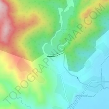
Name: Singda Dam topographic map, elevation, terrain.
Location: Singda Dam, Saitu-Gamphazol, Kangpokpi, Manipur, India (24.88209 93.80260 24.88309 93.80752)
Average elevation: 948 m
Minimum elevation: 817 m
Maximum elevation: 1,174 m
Make a donation
Other topographic maps
Click on a map to view its topography, its elevation and its terrain.
Make a donation
Thoubal
The district occupies the larger part of the eastern half of the Manipur Valley. The shape of the district is an irregular triangle with its base facing north. It lies between 23° 45' – 24° 45' North latitudes and 93° 45' – 94° 15' East longitudes. Its average elevation is about 790 m above the sea…
Average elevation: 813 m
Make a donation
Make a donation
Make a donation
Make a donation
Senapati
Senapati District is located between 93.29° and 94.15° East Longitude and 24.37° and 25.37° North Latitude and is in the northern part of Manipur state. The District is bounded on the south by Kangpokpi District, on the east by Ukhrul district, on the west by Tamenglong district and on the north by Kohima…
Average elevation: 1,454 m
Make a donation
Make a donation
Make a donation
Make a donation
Make a donation
Make a donation
Make a donation