
Squamish-Lillooet topographic map
Interactive map
Click on the map to display elevation.
About this map
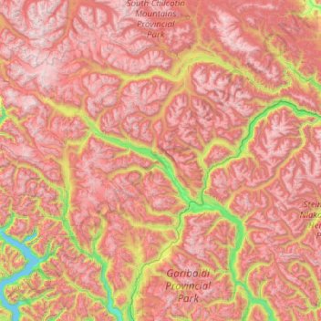
Name: Squamish-Lillooet topographic map, elevation, terrain.
Location: Squamish-Lillooet, British Columbia, Canada (49.84975 -123.62601 51.12975 -122.34601)
Average elevation: 1,545 m
Minimum elevation: 0 m
Maximum elevation: 3,103 m
Other topographic maps
Click on a map to view its topography, its elevation and its terrain.
Lytton
Canada > British Columbia > Thompson-Nicola Regional District
Lytton experiences an inland hot-summer mediterranean climate (Csa), using the -3 °C isotherm, or a dry-summer continental climate (Dsa), using the 0 °C isotherm. During summer heat waves, Lytton is often the hottest spot in Canada, despite its location north of 50°N in latitude. Because of the dry summer…
Average elevation: 523 m
Mount Pleasant
Canada > British Columbia > Metro Vancouver Regional District > Vancouver
Average elevation: 28 m
Mistake Island
Canada > British Columbia > Regional District of Mount Waddington > Area A (Seymour Inlet/Knight Inlet)
Average elevation: 24 m
Map Glacier
Canada > British Columbia > Cariboo Regional District > Area J (West Chilcotin)
Average elevation: 2,037 m
Coquitlam
Canada > British Columbia > Metro Vancouver Regional District
Like much of Metro Vancouver, Coquitlam has an oceanic climate (Köppen climate type Cfb), experiencing mild temperatures and high precipitation; warm, dry summers and cool, wet winters. However, compared to most other cities in the area, precipitation is especially heavy in Coquitlam due to its proximity to…
Average elevation: 190 m
Alah Lake
Canada > British Columbia > Cariboo Regional District > Area F (Horsefly/Likely/150 Mile House)
Average elevation: 841 m
Gabriola Island
Canada > British Columbia > Regional District of Nanaimo > Area B (DeCourcy/Gabriola/Mudge)
Gabriola is about 14 kilometres (9 mi) long by 4.2 kilometres (2.6 mi) wide on average with a land area of 57.6 square kilometres (22.2 sq mi). The topography varies from flat sandy beaches at sea level to forested hills rising to 160 metres (525 ft) on Stoney Ridge in the centre of the island.
Average elevation: 26 m
Lake Country
Canada > British Columbia > Regional District of Central Okanagan
Average elevation: 650 m
Southgate River
Canada > British Columbia > Strathcona Regional District > Area B (Discovery Islands/Mainland Inlets)
Average elevation: 1,787 m
Osoyoos
Canada > British Columbia > Regional District of Okanagan-Similkameen
Average elevation: 326 m
Area B (Shelter Bay/Mica Creek)
Canada > British Columbia > Columbia-Shuswap Regional District
Average elevation: 1,555 m
Mount Revelstoke National Park
Canada > British Columbia > Columbia-Shuswap Regional District > Area B (Shelter Bay/Mica Creek)
Average elevation: 1,477 m
Bowen Island Municipality
Canada > British Columbia > Metro Vancouver Regional District
Average elevation: 95 m
Victoria
Canada > British Columbia > Capital Regional District
Victoria, British Columbia, is situated on the southern tip of Vancouver Island, Canada, and boasts a diverse and varied topography. The city is characterized by rolling hills, rugged coastal cliffs, and lush valleys, providing a striking contrast between mountainous terrain and flatland areas. To the north…
Average elevation: 17 m
New Hazelton
Canada > British Columbia > Regional District of Kitimat-Stikine
Average elevation: 404 m
Big Corvette Island
Canada > British Columbia > Central Coast Regional District > Area A (Ocean Falls/Outer Coast)
Average elevation: 11 m
Area A (Egmont/Pender Harbour)
Canada > British Columbia > Sunshine Coast Regional District
Average elevation: 849 m
Half Moon Beach
Canada > British Columbia > Area F (McConnell Creek/Hatzic Prairie)
Average elevation: 575 m
Area D (Kiskatinaw Valley)
Canada > British Columbia > Peace River Regional District
Average elevation: 1,024 m
Kelowna
Canada > British Columbia > Regional District of Central Okanagan > Kelowna
Kelowna is classified as a humid continental climate or an inland oceanic climate per the Köppen climate classification system due to its coldest month having an average temperature slightly above −3.0 °C (26.6 °F) and below 0 °C (32 °F), with dry, hot, sunny summers and cool, cloudy winters, and four…
Average elevation: 704 m
Burnaby
Canada > British Columbia > Metro Vancouver Regional District > Burnaby
Burnaby occupies 98.6 square kilometres (38.1 sq mi) and is located at the geographic centre of the Metro Vancouver Regional District. The regional district's government is located in Burnaby's Metrotown area. Situated between the city of Vancouver on the west and Port Moody, Coquitlam, and New Westminster on…
Average elevation: 59 m
Slave Island
Canada > British Columbia > Regional District of Mount Waddington > Area B (Quatsino Sound/Cape Scott)
Average elevation: 15 m
Juan de Fuca Electoral Area
Canada > British Columbia > Juan de Fuca Electoral Area
Average elevation: 255 m
Sun Peaks Mountain Resort Municipality
Canada > British Columbia > Sun Peaks Mountain Resort Municipality
Average elevation: 1,589 m
Trail
Canada > British Columbia > Regional District of Kootenay Boundary > Trail
Average elevation: 887 m
Burns Lake
Canada > British Columbia > Regional District of Bulkley-Nechako > Burns Lake
Average elevation: 942 m
Terrace
Canada > British Columbia > Regional District of Kitimat-Stikine > Terrace
Average elevation: 131 m
Abbotsford
Canada > British Columbia > Fraser Valley Regional District > Abbotsford
Average elevation: 99 m