Geolocate

Seoul topographic map

Interactive map

Click on the map to display elevation.

About this map

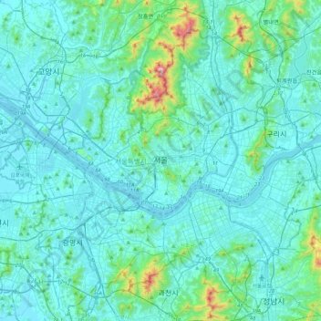
Name: Seoul topographic map, elevation, terrain.

Location: Seoul, South Korea (37.42854 126.76443 37.70148 127.18377)

Average elevation: 80 m

Minimum elevation: 1 m

Maximum elevation: 810 m

Other topographic maps

Click on a map to view its topography, its elevation and its terrain.

Cheonggyecheon (Stream)

South Korea > Seoul

Average elevation: 32 m

Daego Reservoir

South Korea > Yeosu-si

Average elevation: 142 m

Sangwangbong

South Korea > Seongju-gun > Gacheon-myeon

Average elevation: 995 m

Haenam-gun

South Korea

Average elevation: 48 m

Chango-ri

South Korea > Gunsan-si

Average elevation: 33 m

597

South Korea > Jeollanam-do > Godal-myeon

Average elevation: 421 m

1089

South Korea

Average elevation: 943 m

Sinpung-dong

South Korea > Gunsan-si > Sinpung-dong

Average elevation: 14 m