
Make a donation
Medchal–Malkajgiri topographic map
Click on the map to display elevation.
Make a donation
About this map
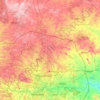
Name: Medchal–Malkajgiri topographic map, elevation, terrain.
Location: Medchal–Malkajgiri, Telangana, India (17.36145 78.34797 17.70855 78.76005)
Average elevation: 557 m
Minimum elevation: 420 m
Maximum elevation: 663 m
Make a donation
Other topographic maps
Click on a map to view its topography, its elevation and its terrain.
Secunderabad
Situated in the North of Hyderabad at 17°27′N 78°30′E / 17.45°N 78.5°E / 17.45; 78.5., Secunderabad lies on the northern part of the Deccan Plateau. Secunderabad has an average elevation of 543 metres (1781 ft). Most of the area has a rocky terrain and some areas are hilly.
Average elevation: 544 m
Make a donation
Make a donation
Make a donation
Make a donation
Make a donation
Make a donation
Make a donation
Make a donation
Make a donation
Make a donation
Make a donation
Make a donation
Nirmal
India > Telangana > Nirmal mandal
Nirmal is located at 19°06′N 78°21′E / 19.10°N 78.35°E / 19.10; 78.35. It has an average elevation of 340 metres (1100 feet) on the foot hills of Nirmal range, which is located in the Deccan plateau.Nirmal has chain tanks built around it.
Average elevation: 335 m
Make a donation
Make a donation
Make a donation
Make a donation
Make a donation
Make a donation
Make a donation
Make a donation
Make a donation
Kothakota
India > Telangana > Kothakota mandal
Kothakota is located at 16°22′39″N 77°56′22″E / 16.377589°N 77.939554°E / 16.377589; 77.939554. It has an average elevation of 401 metres (1318 ft).
Average elevation: 349 m
Make a donation
Make a donation
Warangal
India > Telangana > Warangal mandal
Warangal is located at 18°00′N 79°35′E / 18.0°N 79.58°E / 18.0; 79.58. It has an average elevation of 266 metres (873 feet). It is settled in the eastern part of Deccan Plateau made up of granite rocks and hill formations which left the region barren making the cultivation dependent on…
Average elevation: 268 m
Kothagudem
India > Telangana > Kothagudem mandal
Kothagudem is located at 17°33′00″N 80°37′05″E / 17.55°N 80.618°E / 17.55; 80.618. It has an average elevation of 89 metres (295 ft) above sea level. The North of Kothagudem borders Chhattisgarh state which is approximately 120 km from the town.
Average elevation: 109 m
Make a donation
Make a donation