
Thank you for supporting this site ❤️
Make a donation
Make a donation
Burgas topographic map
Click on the map to display elevation.
Thank you for supporting this site ❤️
Make a donation
Make a donation
About this map
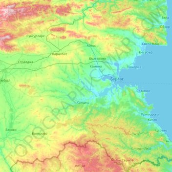
Name: Burgas topographic map, elevation, terrain.
Location: Burgas, Bulgaria (41.90441 26.57865 42.98470 28.03575)
Average elevation: 221 m
Minimum elevation: -4 m
Maximum elevation: 1,026 m
Thank you for supporting this site ❤️
Make a donation
Make a donation
Other topographic maps
Click on a map to view its topography, its elevation and its terrain.
Thank you for supporting this site ❤️
Make a donation
Make a donation
Thank you for supporting this site ❤️
Make a donation
Make a donation
Bansko
Bansko (Bulgarian: Банско [ˈbansko]) is a town in southwestern Bulgaria, located at the foot of the Pirin Mountains at an elevation of 1200m above sea level. It is a ski resort.
Average elevation: 1,034 m