
Make a donation
Mary topographic map
Click on the map to display elevation.
Make a donation
About this map
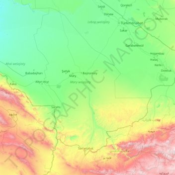
Name: Mary topographic map, elevation, terrain.
Location: Mary, Turkmenistan (34.53029 59.80195 39.73029 65.00195)
Average elevation: 625 m
Minimum elevation: 96 m
Maximum elevation: 3,670 m
Make a donation
Other topographic maps
Click on a map to view its topography, its elevation and its terrain.
Ashgabat
Ashgabat is very close to the border with Iran. It occupies a highly seismically active oasis plain bounded on the south by the foothills of the Kopet Dag mountains (Turkmen: Köpetdag) and on the north by the Karakum Desert. It is surrounded by, but not part of, Ahal Province (Turkmen: Ahal welaýaty). The…
Average elevation: 467 m
Make a donation
Turkmenbashy
Türkmenbaşy (Turkmen Cyrillic: Түркменбашы, Turkmen Arabic; توركمنباشی, also spelled Turkmenbashy and Turkmenbashi, the latter a back-formation of Russian Cyrillic Туркменбаши), formerly known as Krasnovodsk (Russian: Красноводск), Kyzyl-Su, and Shagadam (Turkmen:…
Average elevation: 16 m
Make a donation
Ashgabat City
Ashgabat is in near proximity, approximately 50 km (30 mi), to the Iranian border. It occupies a highly seismically active oasis plain bounded on the south by the foothills of the Kopet Dag mountains (Turkmen: Köpetdag) and on the north by the Karakum Desert. It is surrounded by, but not part of, Ahal…
Average elevation: 467 m
Make a donation
Make a donation
Make a donation
Turkmenbashy
Türkmenbaşy, previously known as Shagadam (Turkmen: Şagadam), Krasnovodsk (Russian: Красноводск) and Kyzyl-Su, is a city in Balkan Province in western Turkmenistan, on the Türkmenbaşy Gulf of the Caspian Sea. It sits at an elevation of 27 metres (89 feet). The population (est 2004) was 86,800,…
Average elevation: 16 m
Make a donation
Make a donation
Ashgabat City
Ashgabat is in near proximity, approximately 50 km (30 mi), to the Iranian border. It occupies a highly seismically active oasis plain bounded on the south by the foothills of the Kopet Dag mountains (Turkmen: Köpetdag) and on the north by the Karakum Desert. It is surrounded by, but not part of, Ahal…
Average elevation: 467 m
Koytendag
Turkmenistan > Koytendag District
Köýtendag is located at an altitude of 265 meters on the banks of the Amu-Darya River, which forms the border with Jowzjan Province, Afghanistan. The Afghan town of Qarqin is on the opposite side of the river. Köýtendag is near the eastern end of Lebap Province, and indeed all of Turkmenistan. The plains…
Average elevation: 277 m
Make a donation
Turkmenabat City
Türkmenabat is located at an altitude of 187 m (614 ft) on the banks of the Amu Darya River, near the border with Uzbekistan. Türkmenabat is at the center of Lebap province, which has borders with three provinces in Turkmenistan: Mary, Ahal and Daşoguz. The province also borders Uzbekistan and Afghanistan.
Average elevation: 194 m
Turkmenbashy
Türkmenbaşy (Turkmen Cyrillic: Түркменбашы, Turkmen Arabic; توركمنباشی, also spelled Turkmenbashy and Turkmenbashi, the latter a back-formation of the Cyrillic Түркменбаши), formerly known as Krasnovodsk (Russian: Красноводск), Kyzyl-Su, and Shagadam (Turkmen:…
Average elevation: 16 m
Make a donation
Make a donation
Ashgabat City
Ashgabat is very close to the border with Iran. It occupies a highly seismically active oasis plain bounded on the south by the foothills of the Kopet Dag mountains (Turkmen: Köpetdag) and on the north by the Karakum Desert. It is surrounded by, but not part of, Ahal Province (Turkmen: Ahal welaýaty). The…
Average elevation: 467 m