
Thank you for supporting this site ❤️
Make a donation
Make a donation
Ahal Region topographic map
Click on the map to display elevation.
Thank you for supporting this site ❤️
Make a donation
Make a donation
About this map
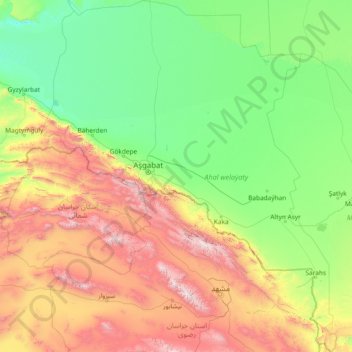
Name: Ahal Region topographic map, elevation, terrain.
Location: Ahal Region, Turkmenistan (35.50560 56.49363 40.20026 61.56913)
Average elevation: 610 m
Minimum elevation: 12 m
Maximum elevation: 3,265 m
Thank you for supporting this site ❤️
Make a donation
Make a donation
Other topographic maps
Click on a map to view its topography, its elevation and its terrain.
Thank you for supporting this site ❤️
Make a donation
Make a donation
Thank you for supporting this site ❤️
Make a donation
Make a donation
Koytendag
Turkmenistan > Koytendag District
Köýtendag is located at an altitude of 265 meters on the banks of the Amu-Darya River, which forms the border with Jowzjan Province, Afghanistan. The Afghan town of Qarqin is on the opposite side of the river. Köýtendag is near the eastern end of Lebap Province, and indeed all of Turkmenistan. The plains…
Average elevation: 277 m
Thank you for supporting this site ❤️
Make a donation
Make a donation
Thank you for supporting this site ❤️
Make a donation
Make a donation