Geolocate

Sukkur District topographic map

Interactive map

Click on the map to display elevation.

About this map

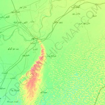
Name: Sukkur District topographic map, elevation, terrain.

Location: Sukkur District, Sukkur Division, Sindh, 65300, Pakistan (27.06955 68.59552 28.02959 69.76023)

Average elevation: 64 m

Minimum elevation: 41 m

Maximum elevation: 163 m

Other topographic maps

Click on a map to view its topography, its elevation and its terrain.

Chelari

Pakistan > Sindh > Umerkot District

Average elevation: 10 m

Jhampir

Pakistan > Sindh > Thatta District

Average elevation: 28 m

Urban Forest

Pakistan > Sindh > Karachi Division > Saddar Town

Average elevation: 9 m

Jamshoro

Pakistan > Sindh > Jamshoro District

Average elevation: 33 m

Chor Cantonment

Pakistan > Sindh > Umerkot District

Average elevation: 12 m

Jhalo

Pakistan > Sindh > Dadu District

Average elevation: 40 m

Oyster Rocks

Pakistan > Sindh > Karachi Division

Average elevation: 22 m

Goth Mubarak Dadu

Pakistan > Sindh > Karachi Division

Average elevation: 24 m

Khipro

Pakistan > Sindh > Sanghar District

Average elevation: 16 m

Karachi

Pakistan > Sindh

Karachi lies very close to a major fault line, where the Indian tectonic plate meets the Arabian tectonic plate. However, Karachi lies near the western edge of the Indian Plate, on the Indo Gagnetic Plain. Within the city of Karachi are two small ranges: the Khasa Hills and Mulri Hills, which lie in the…

Average elevation: 20 m

Jampar

Pakistan > Sindh

Average elevation: 38 m

Kidney Hill Park

Pakistan > Sindh > Gulshan Town > Al Hamra

Average elevation: 34 m

Kokan Family Park

Pakistan > Sindh > Gulshan Town

Average elevation: 33 m

Wakro

Pakistan > Sindh

Average elevation: 51 m

Golarchi

Pakistan > Sindh

Average elevation: 9 m

Indus River (branch)

Pakistan > Sindh > Sukkur

Average elevation: 61 m

Dadu

Pakistan > Sindh

Average elevation: 40 m

Mohenjo-daro

Pakistan > Sindh > Hasan Wahan

Average elevation: 50 m

Hyderabad

Pakistan > Sindh > Hyderabad

Located at 25.367 °N latitude and 68.367 °E longitude with an elevation of 13 metres (43 ft), Hyderabad is located on the east bank of the Indus River and is roughly 150 kilometres (93 mi) away from Karachi, the provincial capital. Two of Pakistan's largest highways, the Indus Highway and the National…

Average elevation: 28 m

Singhara

Pakistan > Sindh > Singhara

Average elevation: 85 m

Indus River

Pakistan > Sindh > Sukkur

Average elevation: 64 m

Kumbhari

Pakistan > Sindh > Kumbhari

Average elevation: 37 m

Lyari Town

Pakistan > Sindh > Karachi

Average elevation: 9 m

Landhi

Pakistan > Sindh > Landhi

Average elevation: 13 m

Modur

Pakistan > Sindh > Diplo > Modur

Average elevation: 36 m

Saddar

Pakistan > Sindh > Karachi > Saddar

Average elevation: 14 m

Borli

Pakistan > Sindh > Tharparkar District > Islamkot > Borli

Average elevation: 51 m