
Ans topographic map
Interactive map
Click on the map to display elevation.
About this map
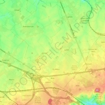
Name: Ans topographic map, elevation, terrain.
Location: Ans, Lüttich, Wallonien, 4430, Belgien (50.64910 5.46101 50.72291 5.55255)
Average elevation: 159 m
Minimum elevation: 99 m
Maximum elevation: 227 m
Other topographic maps
Click on a map to view its topography, its elevation and its terrain.
Fort de Pontisse
Belgien > Lüttich > Lüttich > Herstal
Fort de Pontisse, Rue de la Ceinture, Pontisse, Herstal, Lüttich, Wallonien, 4040, Belgien
Average elevation: 99 m
Grâce-Berleur
Belgien > Lüttich > Lüttich > Grâce-Berleur
Grâce-Berleur, Grâce-Hollogne, Lüttich, Wallonien, 4460, Belgien
Average elevation: 137 m
Remouchamps
Belgien > Lüttich > Lüttich > Aywaille > Remouchamps
Remouchamps, Aywaille, Lüttich, Wallonien, 4920, Belgien
Average elevation: 222 m