
Make a donation
Owen County topographic map
Click on the map to display elevation.
Make a donation
About this map
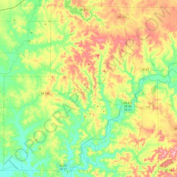
Name: Owen County topographic map, elevation, terrain.
Location: Owen County, Indiana, United States (39.16575 -87.05492 39.47335 -86.63072)
Average elevation: 206 m
Minimum elevation: 151 m
Maximum elevation: 297 m
Make a donation
Other topographic maps
Click on a map to view its topography, its elevation and its terrain.
Indianapolis
United States > Indiana > Indianapolis
Indianapolis is within the Tipton Till Plain, a flat to gently sloping terrain underlain by glacial deposits known as till. The lowest point in the city is about 650 feet (198 m) above mean sea level, with the highest natural elevation at about 900 feet (274 m) above sea level. Few hills or short ridges, known…
Average elevation: 241 m
Brown County State Park
United States > Indiana > Nashville
Brown County State Park is sometimes called "the Little Smokies" because of similarities with the Smokey Mountains. Activities available in the park include camping, fishing, biking, hiking, and seasonal horseback riding. Many of these activities are available all year. Overnight visitors may stay in the…
Average elevation: 224 m
Connersville
United States > Indiana > Fayette County > Connersville
Most of the town is located on the north bank of the west fork of the Whitewater River. The town is at modest elevation, a little over 800 feet (240 m) above sea level. The local area has nearly flat to gently rolling topography. The local region (and all of Fayette County and the state of Indiana) are part of…
Average elevation: 269 m
Make a donation
Make a donation
Make a donation
Make a donation
Make a donation
Make a donation
Make a donation
Make a donation
Make a donation
Make a donation
Make a donation
Make a donation
Make a donation
Make a donation
Make a donation
Make a donation
Make a donation
Make a donation
Make a donation
Make a donation
Make a donation
Make a donation
Make a donation
Make a donation
Make a donation