
Make a donation
Porter topographic map
Click on the map to display elevation.
Make a donation
About this map
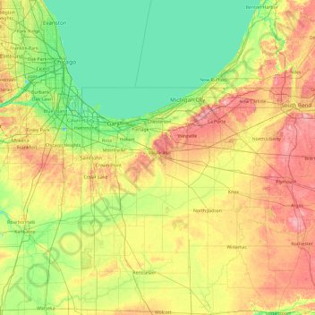
Name: Porter topographic map, elevation, terrain.
Location: Porter, Indiana, 46385, United States (40.74570 -87.77250 42.14570 -86.37250)
Average elevation: 207 m
Minimum elevation: 171 m
Maximum elevation: 286 m
Make a donation
Other topographic maps
Click on a map to view its topography, its elevation and its terrain.
Make a donation
Make a donation
Make a donation
Daviess County
The terrain of Daviess County is hilly, with its area completely devoted to agriculture or urban development. Its highest elevation (740'/266 meters ASL) is a rise one mile (1.6 km) NNE of Farlen. The county is drained by the White River flowing to the southwest, whose two main forks (East White and West…
Average elevation: 154 m
Make a donation
Make a donation
Make a donation
Fort Harrison State Park
United States > Indiana > Marion County > Indianapolis
Average elevation: 251 m
Make a donation
Make a donation
Make a donation
Make a donation
Bremen
United States > Indiana > Marshall County
Bremen is located in northeastern Marshall County at 41°26′50″N 86°08′58″W / 41.447109°N 86.149342°W / 41.447109; -86.149342. It is at an elevation of 854 feet (260 m).
Average elevation: 252 m
Make a donation
Make a donation
Make a donation
Make a donation
Make a donation
Make a donation
Make a donation
Make a donation
Make a donation
Parker City
United States > Indiana > Randolph County
According to the 2010 census, Parker City has a total area of 0.57 square miles (1.48 km2), all land. It is located at an elevation of 1025 feet.
Average elevation: 312 m
Make a donation
Make a donation
Make a donation
Make a donation
Make a donation
Make a donation