
Po Valley topographic map
Interactive map
Click on the map to display elevation.
Po Valley
The altitude of the valley through which the Po flows, exclusive of its tributaries, varies from approximately 4 m (15 feet) below sea level in the Polesine subregion (the delta around Ferrara) to about 2,100 m (6,900 feet) at the river's origin in the southern Piedmontese province of Cuneo, also known as the Provincia granda. The valley is crossed by a number of affluents running down from the Alps in the north and from the Apennines in the south. The Po's major affluents include the Tanaro, Scrivia, Trebbia, Panaro and Secchia in the south, Dora Riparia, Dora Baltea, Sesia, Ticino (draining Lake Maggiore), Lambro, Adda (draining Lake Como), Oglio (draining Lake Iseo) and Mincio (draining Lake Garda and called Sarca in its upper reaches) in the north.
About this map
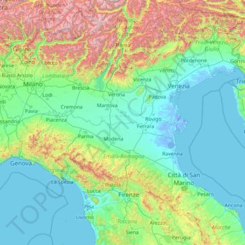
Name: Po Valley topographic map, elevation, terrain.
Location: Po Valley, Italy (44.03875 7.28861 45.84980 12.56358)
Average elevation: 500 m
Minimum elevation: -6 m
Maximum elevation: 3,828 m
Other topographic maps
Click on a map to view its topography, its elevation and its terrain.
Tre Cime di Lavaredo - Drei Zinnen
Italy > Veneto > Belluno > Auronzo di Cadore
Until 1919 the peaks formed part of the border between Italy and Austria-Hungary. Now they lie on the border between the Italian provinces of South Tyrol and Belluno and still are a part of the linguistic boundary between German-speaking and Italian-speaking majorities. The Cima Grande has an elevation of…
Average elevation: 2,242 m
Graun im Vinschgau - Curon Venosta
Italy > Trentino – Alto Adige/Südtirol > South Tyrol > Graun - Curon Venosta
Average elevation: 1,794 m
Rein in Taufers - Riva di Tures
Italy > Trentino – Alto Adige/Südtirol > South Tyrol
Average elevation: 1,981 m
Monte Cusna
Italy > Emilia-Romagna > Reggio nell'Emilia > Villa Minozzo
The mountain is located along the Appennino Crest Trail (A00) between Cerreto and Lagastrello Passes, with an altitude of 2,120 metres (6,960 ft). It is also known as Uomo Morto (Italian: "Dead Man"), "Uomo che Dorme" ("Sleeping Man") or "Il Gigante" ("The Giant") for its appearance, resembling a lying man.
Average elevation: 1,721 m
Ellen - Elle
Italy > Trentino-Alto Adige/Südtirol > South Tyrol > St. Lorenzen - San Lorenzo di Sebato
Average elevation: 1,348 m
Pineta - Steinmannwald
Italy > Trentino-Alto Adige/Südtirol > South Tyrol > Laives - Leifers
Average elevation: 549 m
Naples
Italy > Campania > Napoli > Naples
The city is situated on the Gulf of Naples, on the western coast of southern Italy; it rises from sea level to an elevation of 450 metres (1,480 ft). The small rivers which formerly crossed the centre of the city have since been covered over by construction. It lies between two notable volcanic regions, Mount…
Average elevation: 58 m
Pawigl - Pavicolo
Italy > Trentino-Alto Adige/Südtirol > South Tyrol > Lana
Average elevation: 1,185 m
Bologna
Italy > Emilia-Romagna > Bologna > Bologna
Bologna is situated on the edge of the Po Plain at the foot of the Apennine Mountains, at the meeting of the Reno and Savena river valleys. As Bologna's two main watercourses flow directly to the sea, the town lies outside of the drainage basin of the River Po. The Province of Bologna stretches from the…
Average elevation: 118 m
Bristie / Brišče
Italy > Friuli Venezia Giulia > Sgonico / Zgonik > Bristie / Brišče
Average elevation: 214 m
Holen - Olmi
Italy > Trentino-Alto Adige/Südtirol > Aldein - Aldino > Holen - Olmi
Average elevation: 1,042 m
Sant'Antonio
Italy > Calabria > Crotone > Isola di Capo Rizzuto > Sant'Antonio
Average elevation: 22 m
Genoa
Italy > Liguria > Genoa > Genoa
The city of Genoa covers an area of 243 square kilometres (94 sq mi) between the Ligurian Sea and the Apennine Mountains. The city stretches along the coast for about 30 kilometres (19 mi) from the neighbourhood of Voltri to Nervi, and for 10 kilometres (6.2 mi) from the coast to the north along the valleys…
Average elevation: 247 m