
Thank you for supporting this site ❤️
Make a donation
Make a donation
Paktia Province topographic map
Click on the map to display elevation.
Thank you for supporting this site ❤️
Make a donation
Make a donation
About this map
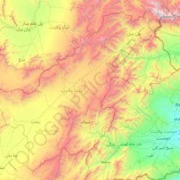
Name: Paktia Province topographic map, elevation, terrain.
Location: Paktia Province, Afghanistan (33.14567 68.76674 34.08644 70.01169)
Average elevation: 2,379 m
Minimum elevation: 1,082 m
Maximum elevation: 4,714 m
Thank you for supporting this site ❤️
Make a donation
Make a donation
Other topographic maps
Click on a map to view its topography, its elevation and its terrain.
Kandahar
Afghanistan > Kandahar Province > Kandahar
Kandahar (English: /ˈkændəˌhɑːr/; Pashto: کندهار Kandahār, Dari: قندهار, Qandahār) is a city in Afghanistan, located in the south of the country on the Arghandab River, at an elevation of 1,010 m (3,310 ft). It is Afghanistan's second largest city after Kabul, with a population of about…
Average elevation: 1,048 m
Thank you for supporting this site ❤️
Make a donation
Make a donation