
Teosa topographic map
Interactive map
Click on the map to display elevation.
About this map
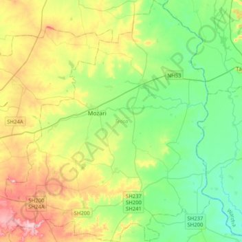
Name: Teosa topographic map, elevation, terrain.
Location: Teosa, Amravati, Maharashtra, India (20.89273 77.88514 21.18813 78.15512)
Average elevation: 338 m
Minimum elevation: 269 m
Maximum elevation: 474 m
Tiosa is located at 21°5′10″N 78°3′50″E / 21.08611°N 78.06389°E / 21.08611; 78.06389. It has an average elevation of 306 metres (1,007 feet).
Other topographic maps
Click on a map to view its topography, its elevation and its terrain.
Jahangirpur
India > Maharashtra > Teosa
Jahangirpur, Teosa, Amravati, Maharashtra, India
Average elevation: 305 m
Bhiwapur
India > Maharashtra > Teosa
Bhiwapur, Teosa, Amravati, Maharashtra, India
Average elevation: 358 m