
Grand Rapids topographic map
Interactive map
Click on the map to display elevation.
About this map
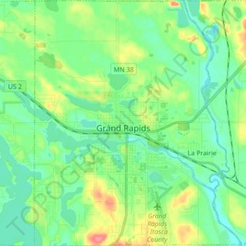
Name: Grand Rapids topographic map, elevation, terrain.
Location: Grand Rapids, Itasca County, Minnesota, 55744, United States (47.19514 -93.57676 47.28229 -93.46832)
Average elevation: 398 m
Minimum elevation: 377 m
Maximum elevation: 448 m
Other topographic maps
Click on a map to view its topography, its elevation and its terrain.
Calumet
United States > Minnesota > Itasca County
Calumet, Itasca County, Minnesota, 55716, United States
Average elevation: 421 m
La Prairie
United States > Minnesota > Itasca County
La Prairie, Itasca County, Minnesota, United States
Average elevation: 393 m
Marie Lake
United States > Minnesota > Itasca County
Marie Lake, Itasca County, Minnesota, United States
Average elevation: 407 m