
Thank you for supporting this site ❤️
Make a donation
Make a donation
Briartown topographic map
Click on the map to display elevation.
Thank you for supporting this site ❤️
Make a donation
Make a donation
About this map
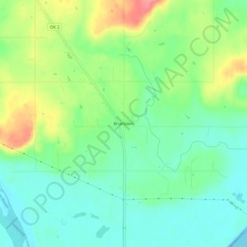
Name: Briartown topographic map, elevation, terrain.
Location: Briartown, Muskogee County, Oklahoma, 74472, United States (35.27774 -95.25876 35.31774 -95.21876)
Average elevation: 172 m
Minimum elevation: 143 m
Maximum elevation: 224 m
Thank you for supporting this site ❤️
Make a donation
Make a donation
Other topographic maps
Click on a map to view its topography, its elevation and its terrain.
Thank you for supporting this site ❤️
Make a donation
Make a donation
Greenleaf State Park
United States > Oklahoma > Muskogee County
According to Caneday et al., the normal elevation of Greenleaf Lake is 510 feet (160 m) above sealevel, and the surface area is 920 acres (3.7 km2). The capacity is rated at 14,720 acre-feet (18,160,000 m3). The shoreline is 14 miles (23 km).
Average elevation: 186 m