
Trongsa District topographic map
Interactive map
Click on the map to display elevation.
About this map
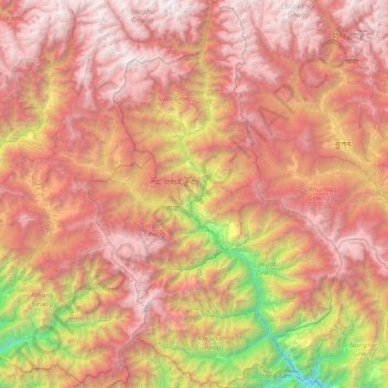
Name: Trongsa District topographic map, elevation, terrain.
Location: Trongsa District, Bhutan (27.13732 90.26176 27.78917 90.74834)
Average elevation: 3,056 m
Minimum elevation: 564 m
Maximum elevation: 5,057 m
Other topographic maps
Click on a map to view its topography, its elevation and its terrain.
Jigmecholing town
Bhutan > Sarpang District > Jigme Chhoeling Gewog > Khamaed
Average elevation: 1,216 m
Thimphu
Bhutan > Thimphu District > Chang Gewog
The city extends in a north–south direction on the west bank of the valley formed by the Wang Chhu, which flows out into India as the Raidāk River. Thimphu is the fifth highest capital in the world by altitude and ranges in altitude from 2,248 metres (7,375 feet) to 2,648 metres (8,688 feet). Unusually for…
Average elevation: 3,121 m
Deothang
Bhutan > Samdrup Jongkhar District > Dewathang Gewog > Chhenangri_Rishor > Deothang
Average elevation: 660 m