
Deogyang-gu topographic map
Interactive map
Click on the map to display elevation.
About this map
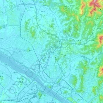
Name: Deogyang-gu topographic map, elevation, terrain.
Location: Deogyang-gu, Goyang-si, Gyeonggi, South Korea (37.57179 126.75959 37.74839 126.99427)
Average elevation: 49 m
Minimum elevation: 0 m
Maximum elevation: 566 m
Other topographic maps
Click on a map to view its topography, its elevation and its terrain.
Deogyang-gu
Deogyang-gu, Goyang-si, Gyeonggi, 10497, South Korea
Average elevation: 23 m
Hyoja-dong
South Korea > Goyang-si > Hyoja-dong
Hyoja-dong, Deogyang-gu, Goyang-si, Gyeonggi, South Korea
Average elevation: 233 m