
Thank you for supporting this site ❤️
Make a donation
Make a donation
Otis topographic map
Click on the map to display elevation.
Thank you for supporting this site ❤️
Make a donation
Make a donation
About this map
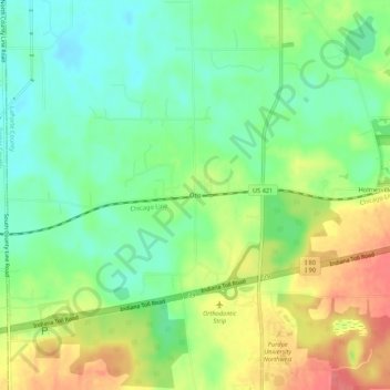
Name: Otis topographic map, elevation, terrain.
Location: Otis, LaPorte County, Indiana, 46391, United States (41.57921 -86.92586 41.61921 -86.88586)
Average elevation: 228 m
Minimum elevation: 200 m
Maximum elevation: 268 m
Thank you for supporting this site ❤️
Make a donation
Make a donation
Other topographic maps
Click on a map to view its topography, its elevation and its terrain.
Thank you for supporting this site ❤️
Make a donation
Make a donation
Thank you for supporting this site ❤️
Make a donation
Make a donation