
Moulmein topographic map
Interactive map
Click on the map to display elevation.
About this map
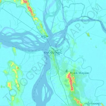
Name: Moulmein topographic map, elevation, terrain.
Location: Moulmein, မော်လမြိုင်ခရိုင်, État Môn, Birmanie (16.36296 97.59003 16.61072 97.70554)
Average elevation: 11 m
Minimum elevation: -3 m
Maximum elevation: 263 m
Other topographic maps
Click on a map to view its topography, its elevation and its terrain.
အစူးချောင်း
အစူးချောင်း, ဘီးလင်း, Thaton District, État Môn, Birmanie
Average elevation: 44 m