
Thaton District topographic map
Interactive map
Click on the map to display elevation.
About this map
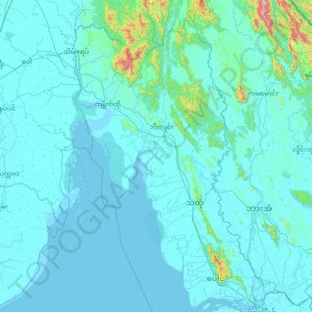
Name: Thaton District topographic map, elevation, terrain.
Location: Thaton District, État Môn, 12021, Birmanie (16.48466 96.86890 17.71763 97.64850)
Average elevation: 53 m
Minimum elevation: -2 m
Maximum elevation: 1,350 m
Other topographic maps
Click on a map to view its topography, its elevation and its terrain.
အစူးချောင်း
အစူးချောင်း, ဘီးလင်း, Thaton District, État Môn, Birmanie
Average elevation: 44 m