
دهستان ماهان topographic map
Interactive map
Click on the map to display elevation.
About this map
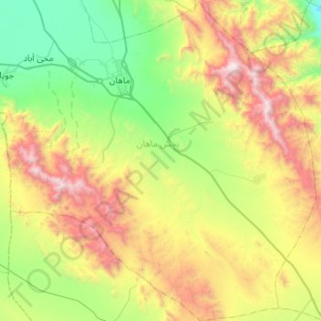
Name: دهستان ماهان topographic map, elevation, terrain.
Location: دهستان ماهان, بخش ماهان, Kerman County, Kerman Province, Iran (29.72972 57.11380 30.15957 57.59265)
Average elevation: 2,525 m
Minimum elevation: 1,656 m
Maximum elevation: 4,201 m
Other topographic maps
Click on a map to view its topography, its elevation and its terrain.
lut lake
Iran > Kerman Province > Kerman County > دهستان تکاب
lut lake, دهستان تکاب, بخش شهداد, Kerman County, Kerman Province, Iran
Average elevation: 262 m
Lut Desert
Iran > Kerman Province > Kerman County > دهستان تکاب
Lut Desert, دهستان تکاب, بخش شهداد, Kerman County, Kerman Province, Iran
Average elevation: 709 m