
Thank you for supporting this site ❤️
Make a donation
Make a donation
Lut Desert topographic map
Click on the map to display elevation.
Thank you for supporting this site ❤️
Make a donation
Make a donation
Lut Desert
The eastern part of Dasht-e Lut is a low plateau covered with salt flats with lowest elevations around 110 m above sea level (30.398609 N, 58.493041 E). In contrast, the center has been sculpted by the wind into a series of parallel ridges and furrows, extending over 150 km (93 mi) and reaching 75 metres (246 ft) in height. This area is also riddled with ravines and sinkholes. The southeast is a vast expanse of sand, like a Saharan erg, with dunes 300 metres (980 ft) high, among the tallest in the world.
Thank you for supporting this site ❤️
Make a donation
Make a donation
About this map
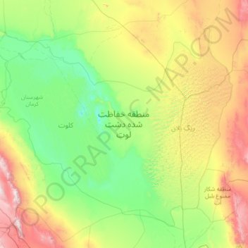
Name: Lut Desert topographic map, elevation, terrain.
Average elevation: 709 m
Minimum elevation: 145 m
Maximum elevation: 2,868 m
Thank you for supporting this site ❤️
Make a donation
Make a donation
Other topographic maps
Click on a map to view its topography, its elevation and its terrain.