
Make a donation
Kabul Province topographic map
Click on the map to display elevation.
Make a donation
Kabul Province
Kabul is located between Latitude 34-31' North and Longitude 69-12' East at an altitude of 1800 m (6000 feet) above sea level, which makes it one of the world's highest capital cities. Kabul is strategically situated in a valley surrounded by high mountains at crossroads of north-south and east-west trade routes. One million years ago the Kabul region was surrounded from south-east between Lowgar and Paghman Mountains; Charikar in the north and the Ningai Ghar mountains in the west. This region formed an icy sea. Some deep wells in the region of today's Poli Charkhi in the east part of city are the evidence of that time. Kabul is surrounded by Koh-e Paghman Mountain from the east, Koh-e Qrough Mountain from the south-west and Koh-e Shirdarwaza Mountain from the north-east. Kabul has only one river which is called Kabul River. Kabul River rises at the Paghman Mountain toward South Pass about 70 km (43 mi) west of Kabul. It flows in an easterly direction, past Kabul, and through Jalalabad city, and then on to Dakka where it enters Pakistani territory and finally runs into the Indus at Attock.
Make a donation
About this map
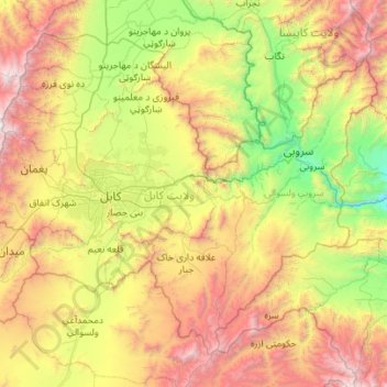
Name: Kabul Province topographic map, elevation, terrain.
Location: Kabul Province, Afghanistan (34.14516 68.83353 34.90711 69.94387)
Average elevation: 2,166 m
Minimum elevation: 804 m
Maximum elevation: 4,727 m
Make a donation
Other topographic maps
Click on a map to view its topography, its elevation and its terrain.
Kandahar
Afghanistan > Kandahar Province > Kandahar
Kandahar (English: /ˈkændəˌhɑːr/; Pashto: کندهار Kandahār, Dari: قندهار, Qandahār) is a city in Afghanistan, located in the south of the country on the Arghandab River, at an elevation of 1,010 m (3,310 ft). It is Afghanistan's second largest city after Kabul, with a population of about…
Average elevation: 1,048 m
Make a donation