
Polk County topographic map
Interactive map
Click on the map to display elevation.
Polk County
The elevation in the county ranges from just under 800 feet (240 m) near the confluence of the Green River and Broad River to over 3,200 feet (980 m) on Tryon Peak and Wildcat Spur, the highest peak in the county. Polk County is divided into two physiographic regions; the Blue Ridge Mountains in the western third of the county and Piedmont for the eastern two-thirds. Since it is in a transition zone between the two regions, Polk County is often referred to as being in the foothills.
About this map
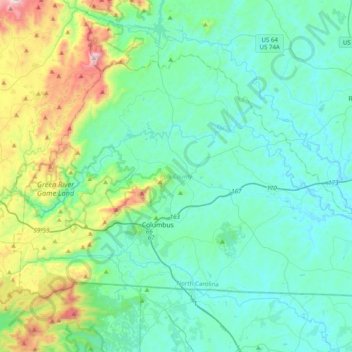
Name: Polk County topographic map, elevation, terrain.
Location: Polk County, North Carolina, United States (35.18508 -82.35926 35.40952 -81.96281)
Average elevation: 414 m
Minimum elevation: 222 m
Maximum elevation: 1,248 m
Other topographic maps
Click on a map to view its topography, its elevation and its terrain.
Siler City Water Supply Lake Number One Dam
United States > North Carolina > Chatham County
Average elevation: 187 m
Appalachian Mountains
United States > North Carolina > Yancey County
The Appalachian Mountains, often called the Appalachians, are a system of mountains in eastern North America. The Appalachians first formed roughly 480 million years ago during the Ordovician Period. They once reached elevations similar to those of the Alps and the Rocky Mountains before experiencing natural…
Average elevation: 1,463 m