
Make a donation
Hunchun topographic map
Click on the map to display elevation.
Make a donation
About this map
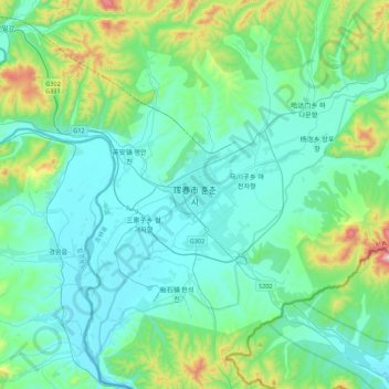
Name: Hunchun topographic map, elevation, terrain.
Location: Hunchun, Hunchun City, Yanbian, Jilin, China (42.69924 130.19910 43.01924 130.51910)
Average elevation: 141 m
Minimum elevation: 17 m
Maximum elevation: 758 m
Make a donation
Other topographic maps
Click on a map to view its topography, its elevation and its terrain.
Make a donation
Changchun City
Changchun lies in the middle portion of the Northeast China Plain. Its municipality area is located at latitude 43° 05′−45° 15′ N and longitude 124° 18′−127° 02' E. The total area of Changchun municipality is 20,571 km2 (7,943 sq mi), including metro areas of 2,583 square kilometres (997 sq mi),…
Average elevation: 215 m
Make a donation
Make a donation
Make a donation