
Thank you for supporting this site ❤️
Make a donation
Make a donation
Tonghua City topographic map
Click on the map to display elevation.
Thank you for supporting this site ❤️
Make a donation
Make a donation
About this map
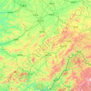
Name: Tonghua City topographic map, elevation, terrain.
Location: Tonghua City, Jilin, 134000, China (40.86183 125.25739 43.01767 126.74388)
Average elevation: 546 m
Minimum elevation: 103 m
Maximum elevation: 2,117 m
Thank you for supporting this site ❤️
Make a donation
Make a donation
Other topographic maps
Click on a map to view its topography, its elevation and its terrain.
Thank you for supporting this site ❤️
Make a donation
Make a donation
Thank you for supporting this site ❤️
Make a donation
Make a donation
Thank you for supporting this site ❤️
Make a donation
Make a donation
Thank you for supporting this site ❤️
Make a donation
Make a donation
Thank you for supporting this site ❤️
Make a donation
Make a donation