
Longjing City topographic map
Interactive map
Click on the map to display elevation.
About this map
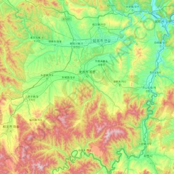
Name: Longjing City topographic map, elevation, terrain.
Location: Longjing City, Yanbian, Jilin, China (42.36049 128.93091 43.05905 129.80385)
Average elevation: 472 m
Minimum elevation: 80 m
Maximum elevation: 1,331 m
Other topographic maps
Click on a map to view its topography, its elevation and its terrain.
Baoping Subdistrict
Baoping Subdistrict, Baicheng, Taobei District, Baicheng City, Jilin, China
Average elevation: 158 m
Longtan District
China > Jilin > Jilin City
Longtan District, Jilin City, Jilin, China
Average elevation: 256 m
Jiangnan
China > Jilin > Dunhua City
Jiangnan, Dunhua City, Yanbian, Jilin, China
Average elevation: 522 m
Ji'an
China > Jilin > Ji'an City > Liming Subdistrict
Ji'an, Liming Subdistrict, Ji'an City, Jilin, China
Average elevation: 474 m
Minzhu Subdistrict
China > Jilin > Jiaohe City > Jilin City
Minzhu Subdistrict, Jiaohe City, Jilin City, Jilin, China
Average elevation: 276 m
Dongning Subdistrict
China > Jilin > Panshi City > Jilin City
Dongning Subdistrict, Panshi City, Jilin City, Jilin, China
Average elevation: 323 m
Qixin Subdistrict
China > Jilin > Huadian City > Jilin City
Qixin Subdistrict, Huadian City, Jilin City, Jilin, China
Average elevation: 269 m
Wangqing
China > Jilin > Wangqing County
Wangqing, Wangqing County, Yanbian, Jilin, China
Average elevation: 314 m
Longshan District
Longshan District, Liaoyuan City, Longshan, Jilin, China
Average elevation: 305 m
Jianguo Subdistrict
Jianguo Subdistrict, Linjiang, Jilin, China
Average elevation: 576 m
Wugongcun
China > Jilin > Tumen City
Wugongcun, Tumen City, Yanbian, Jilin, China
Average elevation: 153 m
Nanguan District
China > Jilin > Changchun City
Nanguan District, Changchun City, Jilin, 130000, China
Average elevation: 241 m
Yongxing Subdistrict
China > Jilin > Changchun City
Yongxing Subdistrict, Nanguan District, Changchun City, Jilin, 130000, China
Average elevation: 228 m
Qian Gorlos Mongol Autonomous County
China > Jilin > Songyuan City
Qian Gorlos Mongol Autonomous County, Songyuan City, Jilin, China
Average elevation: 167 m
Gongzhuling City
China > Jilin > Gongzhuling City > Changchun City
Gongzhuling City, Changchun City, Jilin, 130000, China
Average elevation: 211 m
Shadong
China > Jilin > Wangqing County > Shadong
Shadong, Wangqing County, Yanbian, Jilin, China
Average elevation: 296 m
Fenjin
China > Jilin > Changchun City > Fenjin
Fenjin, Kuancheng District, Changchun City, Jilin, 130000, China
Average elevation: 207 m
Yitong Manchu Autonomous County
China > Jilin > Siping City
Yitong Manchu Autonomous County, Siping City, Jilin, China
Average elevation: 278 m
Yanbian Korean Autonomous Prefecture
Yanbian Korean Autonomous Prefecture, Jilin, 133000, China
Average elevation: 573 m
Baicheng
China > Jilin > Changqing Subdistrict
Baicheng, Changqing Subdistrict, Taobei District, Baicheng City, Jilin, China
Average elevation: 156 m
Chagan Lake
Chagan Lake, Da'an City, Baicheng City, Jilin, China
Average elevation: 133 m