
Sneaton topographic map
Click on the map to display elevation.
About this map
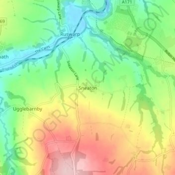
Name: Sneaton topographic map, elevation, terrain.
Location: Sneaton, North Yorkshire, England, YO22 5HS, United Kingdom (54.43764 -0.64186 54.47764 -0.60186)
Average elevation: 85 m
Minimum elevation: -1 m
Maximum elevation: 211 m
Other topographic maps
Click on a map to view its topography, its elevation and its terrain.
Middleham
United Kingdom > England > North Yorkshire
The town lies between 400 and 500 feet (120 and 150 m) above ordnance datum. The valley of the River Ure below the town has an altitude of 325 feet (99 m) and the summit of the hill to the south-west of the town of 850 feet (260 m). The parish contains 2,155 acres (872 ha) of land, mostly permanent pasture…
Average elevation: 157 m
Scarborough
United Kingdom > England > North Yorkshire > Scarborough
The climate is temperate with mild summers and cool, windy, winters. The hottest months of the year are July and August, with temperatures reaching an average high of 17 °C and falling to 11 °C at night. The average daytime temperatures in January are 4 °C, falling to 1 °C at night. The station's elevation…
Average elevation: 50 m