
Middleham topographic map
Click on the map to display elevation.
Middleham
The town lies between 400 and 500 feet (120 and 150 m) above ordnance datum. The valley of the River Ure below the town has an altitude of 325 feet (99 m) and the summit of the hill to the south-west of the town of 850 feet (260 m). The parish contains 2,155 acres (872 ha) of land, mostly permanent pasture with about 150 acres (61 ha) arable. The topsoil is mixed. The valley has modern alluvial terraces and gravel deposits, but the subsoil is mainly limestone, intersected here and there by sandstone with plate. There is a known vein of lead in the northern part of the parish. Braithwaite lead mine lies just outside the parish borders.
About this map
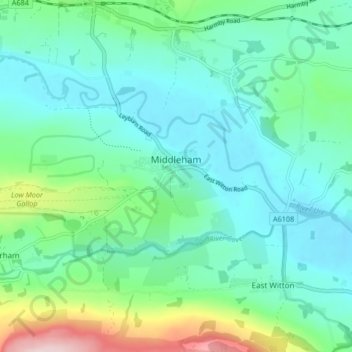
Name: Middleham topographic map, elevation, terrain.
Location: Middleham, North Yorkshire, England, United Kingdom (54.27034 -1.86574 54.29837 -1.78292)
Average elevation: 157 m
Minimum elevation: 95 m
Maximum elevation: 378 m
Other topographic maps
Click on a map to view its topography, its elevation and its terrain.
Greenhow Hill
United Kingdom > England > North Yorkshire
The village is about 3 miles (4.8 km) west of Pateley Bridge on the road heading towards Grassington, and is mainly in the civil parish of Bewerley. However, the western end of the village lying to the west of Kell Dyke, commonly known as Craven Cross, lies within the civil parish of Appletreewick in Craven.…
Average elevation: 358 m