
Thank you for supporting this site ❤️
Make a donation
Make a donation
Chilton County topographic map
Click on the map to display elevation.
Thank you for supporting this site ❤️
Make a donation
Make a donation
About this map
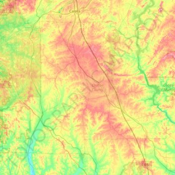
Name: Chilton County topographic map, elevation, terrain.
Location: Chilton County, Alabama, United States (32.66007 -87.01916 33.07181 -86.37347)
Average elevation: 153 m
Minimum elevation: 60 m
Maximum elevation: 289 m
Thank you for supporting this site ❤️
Make a donation
Make a donation
Other topographic maps
Click on a map to view its topography, its elevation and its terrain.
Thank you for supporting this site ❤️
Make a donation
Make a donation
Thank you for supporting this site ❤️
Make a donation
Make a donation