
Thank you for supporting this site ❤️
Make a donation
Make a donation
Stigler topographic map
Click on the map to display elevation.
Thank you for supporting this site ❤️
Make a donation
Make a donation
About this map
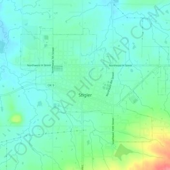
Name: Stigler topographic map, elevation, terrain.
Location: Stigler, Haskell County, Oklahoma, 74462, United States (35.24252 -95.14193 35.26958 -95.09240)
Average elevation: 176 m
Minimum elevation: 157 m
Maximum elevation: 235 m
Thank you for supporting this site ❤️
Make a donation
Make a donation
Other topographic maps
Click on a map to view its topography, its elevation and its terrain.