
Wenchang City topographic map
Interactive map
Click on the map to display elevation.
About this map
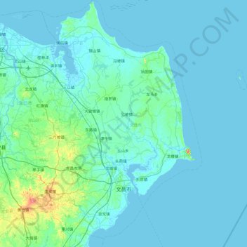
Name: Wenchang City topographic map, elevation, terrain.
Location: Wenchang City, Hainan Province, China (19.35224 110.46432 20.16562 111.28413)
Average elevation: 19 m
Minimum elevation: -3 m
Maximum elevation: 291 m
Other topographic maps
Click on a map to view its topography, its elevation and its terrain.
Baisha Li Autonomous County
Baisha Li Autonomous County, Hainan Province, China
Average elevation: 368 m
Yinggen
China > Hainan Province > Qiongzhong Li and Miao Autonomous County
Yinggen, Qiongzhong Li and Miao Autonomous County, Hainan Province, China
Average elevation: 308 m
Qiongshan District
China > Hainan Province > Haikou City
Qiongshan District, Haikou City, Hainan Province, 571138, China
Average elevation: 47 m
Wuzhizhou Island
China > Hainan Province > Haitang District
Wuzhizhou Island, Haitang District, Sanya City, Hainan Province, China
Average elevation: 3 m
Dapo
China > Hainan Province > Haikou City
Dapo, Haikou City, Hainan Province, China
Average elevation: 79 m
Longhua District
Longhua District, Haikou City, Hainan Province, China, BS9
Average elevation: 4 m
BS15
China > Hainan Province > Longhua District
BS15, Longhua District, Haikou City, Hainan Province, China
Average elevation: 4 m
Jiaji
China > Hainan Province > Qionghai City
Jiaji, Qionghai City, Hainan Province, 571400, China
Average elevation: 15 m
Jinjiang
China > Hainan Province > Chengmai County
Jinjiang, Chengmai County, Hainan Province, China
Average elevation: 53 m
Longhua District
Longhua District, Haikou City, Hainan Province, China
Average elevation: 33 m
Yangpu Peninsula
China > Hainan Province > Danzhou City > Yancun
Yangpu Peninsula, Yancun, Danzhou City, Hainan Province, China
Average elevation: 10 m
Nansha District
China > Hainan Province > Nansha District
Nansha District, Sansha, Hainan Province, China
Average elevation: 0 m
Qiongzhong Li and Miao Autonomous County
China > Hainan Province > Qiongzhong Li and Miao Autonomous County
Qiongzhong Li and Miao Autonomous County, Hainan Province, China
Average elevation: 420 m
Baoting Li and Miao Autonomous County
China > Hainan Province > Baoting Li and Miao Autonomous County
Baoting Li and Miao Autonomous County, Hainan Province, China
Average elevation: 376 m
Chengmai County
China > Hainan Province > Chengmai County
Chengmai County, Hainan Province, China
Average elevation: 64 m
Lingshui Li Autonomous County
China > Hainan Province > Lingshui Li Autonomous County
Lingshui Li Autonomous County, Hainan Province, China
Average elevation: 62 m
Danzhou City
China > Hainan Province > Danzhou City > Danzhou City
Danzhou City, Hainan Province, China
Average elevation: 150 m