Geolocate

Baoting Li and Miao Autonomous County topographic map

Interactive map

Click on the map to display elevation.

About this map

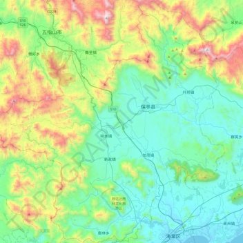
Name: Baoting Li and Miao Autonomous County topographic map, elevation, terrain.

Location: Baoting Li and Miao Autonomous County, Hainan Province, 572316, China (18.38865 109.40041 18.83512 109.84792)

Average elevation: 376 m

Minimum elevation: -4 m

Maximum elevation: 1,440 m

Other topographic maps

Click on a map to view its topography, its elevation and its terrain.

Dadonghai

China > Hainan Province > Jiyang District

Average elevation: 15 m

Mischief Reef

China > Hainan Province > Sansha

Mischief Reef, also known as Panganiban Reef (Filipino: Bahura ng Panganiban; Vietnamese: Đá Vành Khăn; Mandarin Chinese: 美濟礁/美济礁; pinyin: Měijì Jiāo; lit. 'Meiji Reef'), is a low tide elevation (LTE) reef/atoll surrounding a large lagoon in the SE of Dangerous Ground in the east of the…

Average elevation: 0 m

Jialai

China > Hainan Province > Lingao County

Average elevation: 82 m

Dapo

China > Hainan Province > Haikou City

Average elevation: 79 m

Longhua District

China > Hainan Province

Average elevation: 4 m

BS15

China > Hainan Province > Longhua District

Average elevation: 4 m

Jiaji

China > Hainan Province > Qionghai City

Average elevation: 15 m

Jinjiang

China > Hainan Province > Chengmai County

Average elevation: 53 m

Ledong

China > Hainan Province

Average elevation: 176 m