
Barishal Division topographic map
Interactive map
Click on the map to display elevation.
About this map
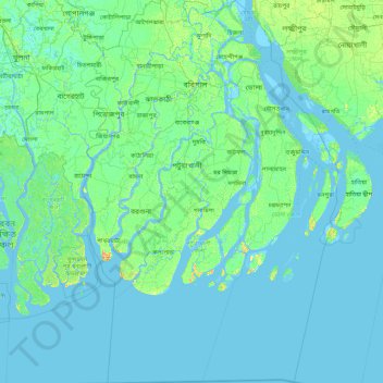
Name: Barishal Division topographic map, elevation, terrain.
Location: Barishal Division, Bangladesh (21.42125 89.84762 23.06076 91.03116)
Average elevation: 3 m
Minimum elevation: -3 m
Maximum elevation: 25 m
Other topographic maps
Click on a map to view its topography, its elevation and its terrain.
Rangamati
Bangladesh > Chattogram Division > Rangamati Sadar Upazila
Rangamati (Bengali: রাঙ্গামাটি is the administrative headquarter and town of Rangamati District in the Chittagong Hill Tracts of Bangladesh. The town is located at 22°37'60N 92°12'0E and has an altitude of 14 metres (46 ft). It was the capital of the Chakma kingdom during the British rule…
Average elevation: 68 m
Brahmaputra River
Bangladesh > Mymensingh Division > Jamalpur Sadar Upazila > Jamalpur
The course of the Brahmaputra River has changed drastically in the past two and a half centuries, moving its river course westwards for a distance of about 80 km (50 mi), leaving its old river course, appropriately named the old Brahmaputra river, behind. In the past, the floodplain of the old river course had…
Average elevation: 18 m
Cox's Bazar
Bangladesh > Chattogram Division
Cox's Bazar lies on a coastal plain in the southeastern corner of Bangladesh. From above, the plain appears to bulge out into the Bay of Bengal. Along the shore is an extensive area of beach and dunes. Most of the city is built on a floodplain that is lower in elevation than the dunes, making it more…
Average elevation: 8 m
Kurigram
Bangladesh > Rangpur Division > Kurigram Sadar Upazila
The town of Kurigram located in the alluvial plain of Teesta-Brahmaputra basin at the bank of Dharla River . The avarage elevation of the town in 31 meter. Kurigram's humid subtropical climate (Köppen Cwa) is influenced by the monsoon and features mild winters and extremely rainy and wet summers. The region…
Average elevation: 27 m
Khal from Moulovi bazar to Dowlatkhan
Bangladesh > Barisal Division > Doulatkhan Subdistrict
Average elevation: 5 m
Mollikpur( Hosenpur) village
Bangladesh > Sylhet Division > Mollikpur( Hosenpur) village
Average elevation: 6 m