
Maramureș topographic map
Interactive map
Click on the map to display elevation.
Maramureș
Maramureș County is situated in the northern part of Romania, in the historical region of Transylvania, and has a border with Ukraine. This county has a total area of 6,304 square kilometres (2,434 sq mi), of which 43% is covered by the Rodna Mountains, with its tallest peak, Pietrosul [ro], at 2,303 metres (7,556 ft) altitude.
About this map
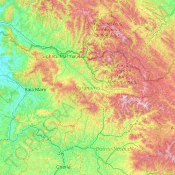
Name: Maramureș topographic map, elevation, terrain.
Location: Maramureș, Romania (47.32062 22.96148 48.02179 25.05644)
Average elevation: 700 m
Minimum elevation: 131 m
Maximum elevation: 2,238 m
Other topographic maps
Click on a map to view its topography, its elevation and its terrain.