Geolocate

Menzel El Habib topographic map

Interactive map

Click on the map to display elevation.

About this map

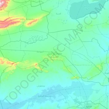
Name: Menzel El Habib topographic map, elevation, terrain.

Location: Menzel El Habib, Gabès, 6030, Tunisie (34.02562 9.24739 34.28262 9.91800)

Average elevation: 102 m

Minimum elevation: 20 m

Maximum elevation: 918 m

Other topographic maps

Click on a map to view its topography, its elevation and its terrain.

Oudref

Tunisie > Gabès > Oudref

Oudref, Ouedhref Sud, El Metouia, Gabès, 6052, Tunisie

Average elevation: 34 m

Gabès

Tunisie > Gabès > Gabès

Gabès, Secteur (3), Gabes Medina, Gabès, 6001, Tunisie

Average elevation: 36 m

El Hamma

Tunisie > Gabès

El Hamma, Gabès, 6062, Tunisie

Average elevation: 120 m

Nouvelle Matmata

Tunisie > Gabès

Nouvelle Matmata, Gabès, Tunisie

Average elevation: 198 m

Matmata

Tunisie > Gabès

Matmata, Gabès, 6070, Tunisie

Average elevation: 263 m

El Metouia

Tunisie > Gabès

El Metouia, Gabès, 6052, Tunisie

Average elevation: 37 m

El Behaier

Tunisie > Gabès

El Behaier, El Hamma, Gabès, 6062, Tunisie

Average elevation: 100 m

Gabes Medina

Tunisie > Gabès

Gabes Medina, Gabès, Tunisie

Average elevation: 10 m