
Thank you for supporting this site ❤️
Make a donation
Make a donation
Habersham topographic map
Click on the map to display elevation.
Thank you for supporting this site ❤️
Make a donation
Make a donation
About this map
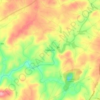
Name: Habersham topographic map, elevation, terrain.
Location: Habersham, Habersham County, Georgia, 30544, United States (34.56982 -83.58045 34.60982 -83.54045)
Average elevation: 409 m
Minimum elevation: 337 m
Maximum elevation: 464 m
Thank you for supporting this site ❤️
Make a donation
Make a donation
Other topographic maps
Click on a map to view its topography, its elevation and its terrain.
Habersham County
United States > Georgia > Habersham County
The highest point in the county is a 4,400-foot (1,300 m) knob less than 700 feet (210 m) southeast of the top of Tray Mountain, the seventh-highest mountain in Georgia. Habersham shares this portion of Tray Mountain, just 30 vertical feet shy of the peak's 4,430-foot summit, with White County to the west and…
Average elevation: 448 m